You are here: Home > Network List > LD - Lamont-Doherty Cooperative Seismographic Network Stations List
> Station PANJ Princeton, NJ > Earthquake Result Viewer
PANJ Princeton, NJ - Earthquake Result Viewer
| Earthquake location: |
Near Coast Of Venezuela |
| Earthquake latitude/longitude: |
10.9/-62.3 |
| Earthquake time(UTC): |
2013/10/12 (285) 02:10:27 GMT |
| Earthquake Depth: |
63 km |
| Earthquake Magnitude: |
6.0 MWW, 6.0 MWW, 6.0 MWB, 6.0 MWC, 6.0 MI |
| Earthquake Catalog/Contributor: |
NEIC PDE/NEIC COMCAT |
|
| Network: |
LD Lamont-Doherty Cooperative Seismographic Network |
| Station: |
PANJ Princeton, NJ |
| Lat/Lon: |
40.38 N/74.70 W |
| Elevation: |
100 m |
|
| Distance: |
31.3 deg |
| Az: |
341.63 deg |
| Baz: |
156.098 deg |
| Ray Param: |
0.07897646 |
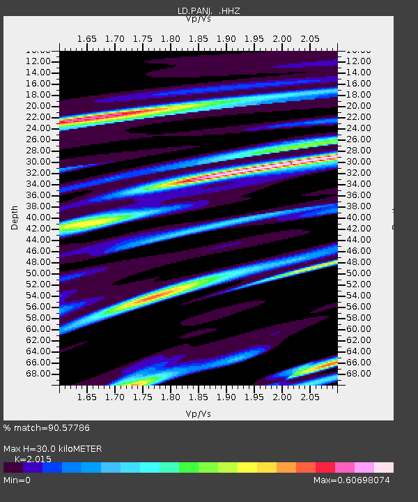
| Estimated Moho Depth: |
30.0 km |
| Estimated Crust Vp/Vs: |
2.02 |
| Assumed Crust Vp: |
6.283 km/s |
| Estimated Crust Vs: |
3.118 km/s |
| Estimated Crust Poisson's Ratio: |
0.34 |
|
| Radial Match: |
90.57786 % |
| Radial Bump: |
280 |
| Transverse Match: |
55.358627 % |
| Transverse Bump: |
400 |
| SOD ConfigId: |
626651 |
| Insert Time: |
2014-04-19 01:32:08.826 +0000 |
| GWidth: |
2.5 |
| Max Bumps: |
400 |
| Tol: |
0.001 |
|

Signal To Noise
| Channel | StoN | STA | LTA |
| LD:PANJ: :HHZ:20131012T02:16:11.507987Z | 4.8176236 | 1.3699614E-6 | 2.8436455E-7 |
| LD:PANJ: :HHN:20131012T02:16:11.507987Z | 4.558922 | 1.0068258E-6 | 2.2084733E-7 |
| LD:PANJ: :HHE:20131012T02:16:11.507987Z | 3.46187 | 4.8384055E-7 | 1.3976276E-7 |
| Arrivals |
| Ps | 5.2 SECOND |
| PpPs | 13 SECOND |
| PsPs/PpSs | 19 SECOND |


