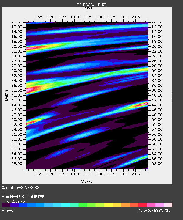
PAGS PA Geological Survey - Earthquake Result Viewer
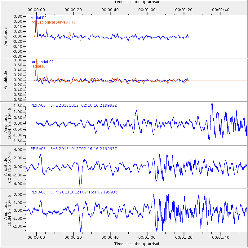
Earthquake location: Near Coast Of Venezuela
Earthquake latitude/longitude: 10.9/-62.3
Earthquake time(UTC): 2013/10/12 (285) 02:10:27 GMT
Earthquake Depth: 63 km
Earthquake Magnitude: 6.0 MWW, 6.0 MWW, 6.0 MWB, 6.0 MWC, 6.0 MI
Earthquake Catalog/Contributor: NEIC PDE/NEIC COMCAT
Network: PE Penn State Network
Station: PAGS PA Geological Survey
Lat/Lon: 40.23 N/76.72 W
Elevation: 120 m
Distance: 31.9 deg
Az: 338.852 deg
Baz: 152.431 deg
Ray Param: 0.07874896
Estimated Moho Depth: 43.0 km
Estimated Crust Vp/Vs: 2.10
Assumed Crust Vp: 6.121 km/s
Estimated Crust Vs: 2.918 km/s
Estimated Crust Poisson's Ratio: 0.35
Radial Match: 82.73688 %
Radial Bump: 331
Transverse Match: 63.412914 %
Transverse Bump: 400
SOD ConfigId: 626651
Insert Time: 2014-04-19 01:35:57.024 +0000
GWidth: 2.5
Max Bumps: 400
Tol: 0.001

Signal To Noise

ChannelStoNSTALTA
PE:PAGS: :BHZ:20131012T02:16:16.219993Z8.1412411.4774349E-61.814754E-7
PE:PAGS: :BHN:20131012T02:16:16.219993Z3.93072255.355461E-71.3624623E-7
PE:PAGS: :BHE:20131012T02:16:16.219993Z2.7997933.513106E-71.2547734E-7
Arrivals
Ps8.2 SECOND
PpPs20 SECOND
PsPs/PpSs29 SECOND