You are here: Home > Network List > PO - Portable Observatories for Lithospheric Analysis and Research Investigating Seis Stations List
> Station ORIO Orleans, Innes Road,, ON > Earthquake Result Viewer
ORIO Orleans, Innes Road,, ON - Earthquake Result Viewer
| Earthquake location: |
Near Coast Of Venezuela |
| Earthquake latitude/longitude: |
10.9/-62.3 |
| Earthquake time(UTC): |
2013/10/12 (285) 02:10:27 GMT |
| Earthquake Depth: |
63 km |
| Earthquake Magnitude: |
6.0 MWW, 6.0 MWW, 6.0 MWB, 6.0 MWC, 6.0 MI |
| Earthquake Catalog/Contributor: |
NEIC PDE/NEIC COMCAT |
|
| Network: |
PO Portable Observatories for Lithospheric Analysis and Research Investigating Seis |
| Station: |
ORIO Orleans, Innes Road,, ON |
| Lat/Lon: |
45.45 N/75.51 W |
| Elevation: |
74 m |
|
| Distance: |
36.2 deg |
| Az: |
344.226 deg |
| Baz: |
157.708 deg |
| Ray Param: |
0.076615006 |
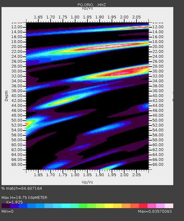
| Estimated Moho Depth: |
19.75 km |
| Estimated Crust Vp/Vs: |
1.92 |
| Assumed Crust Vp: |
6.419 km/s |
| Estimated Crust Vs: |
3.335 km/s |
| Estimated Crust Poisson's Ratio: |
0.32 |
|
| Radial Match: |
84.687164 % |
| Radial Bump: |
336 |
| Transverse Match: |
56.864136 % |
| Transverse Bump: |
400 |
| SOD ConfigId: |
626651 |
| Insert Time: |
2014-04-19 01:37:30.741 +0000 |
| GWidth: |
2.5 |
| Max Bumps: |
400 |
| Tol: |
0.001 |
|

Signal To Noise
| Channel | StoN | STA | LTA |
| PO:ORIO: :HHZ:20131012T02:16:53.879996Z | 3.1811428 | 4.2719262E-7 | 1.3428904E-7 |
| PO:ORIO: :HHN:20131012T02:16:53.879996Z | 3.875398 | 3.0571596E-7 | 7.8886345E-8 |
| PO:ORIO: :HHE:20131012T02:16:53.879996Z | 1.301855 | 1.1998341E-7 | 9.216342E-8 |
| Arrivals |
| Ps | 3.0 SECOND |
| PpPs | 8.4 SECOND |
| PsPs/PpSs | 11 SECOND |


