You are here: Home > Network List > TA - USArray Transportable Network (new EarthScope stations) Stations List
> Station D62A Allapoint, Allagash, ME, USA > Earthquake Result Viewer
D62A Allapoint, Allagash, ME, USA - Earthquake Result Viewer
| Earthquake location: |
Near Coast Of Venezuela |
| Earthquake latitude/longitude: |
10.9/-62.3 |
| Earthquake time(UTC): |
2013/10/12 (285) 02:10:27 GMT |
| Earthquake Depth: |
63 km |
| Earthquake Magnitude: |
6.0 MWW, 6.0 MWW, 6.0 MWB, 6.0 MWC, 6.0 MI |
| Earthquake Catalog/Contributor: |
NEIC PDE/NEIC COMCAT |
|
| Network: |
TA USArray Transportable Network (new EarthScope stations) |
| Station: |
D62A Allapoint, Allagash, ME, USA |
| Lat/Lon: |
47.08 N/69.05 W |
| Elevation: |
189 m |
|
| Distance: |
36.5 deg |
| Az: |
352.257 deg |
| Baz: |
168.835 deg |
| Ray Param: |
0.07646813 |
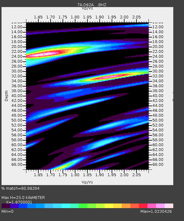
| Estimated Moho Depth: |
23.0 km |
| Estimated Crust Vp/Vs: |
1.67 |
| Assumed Crust Vp: |
6.419 km/s |
| Estimated Crust Vs: |
3.844 km/s |
| Estimated Crust Poisson's Ratio: |
0.22 |
|
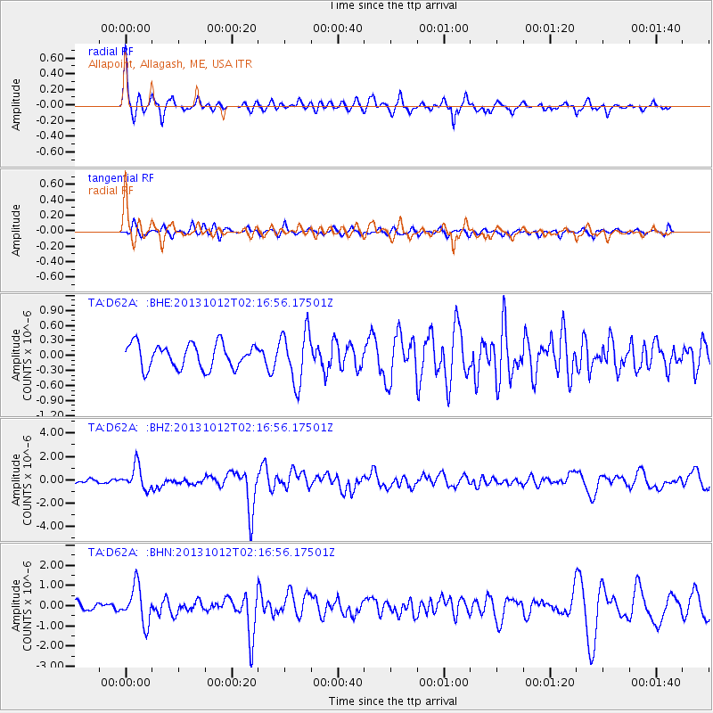
| Radial Match: |
80.86284 % |
| Radial Bump: |
373 |
| Transverse Match: |
66.236626 % |
| Transverse Bump: |
366 |
| SOD ConfigId: |
626651 |
| Insert Time: |
2014-04-19 01:40:05.341 +0000 |
| GWidth: |
2.5 |
| Max Bumps: |
400 |
| Tol: |
0.001 |
|
Signal To Noise
| Channel | StoN | STA | LTA |
| TA:D62A: :BHZ:20131012T02:16:56.17501Z | 6.2900753 | 1.0068261E-6 | 1.6006582E-7 |
| TA:D62A: :BHN:20131012T02:16:56.17501Z | 6.368708 | 9.2756267E-7 | 1.4564378E-7 |
| TA:D62A: :BHE:20131012T02:16:56.17501Z | 2.1874523 | 5.2543714E-7 | 2.402051E-7 |
| Arrivals |
| Ps | 2.6 SECOND |
| PpPs | 8.8 SECOND |
| PsPs/PpSs | 11 SECOND |


