You are here: Home > Network List > II - Global Seismograph Network (GSN - IRIS/IDA) Stations List
> Station TLY Talaya, Russia > Earthquake Result Viewer
TLY Talaya, Russia - Earthquake Result Viewer

| Earthquake location: |
Dodecanese Islands, Greece |
| Earthquake latitude/longitude: |
35.8/27.9 |
| Earthquake time(UTC): |
2008/07/15 (197) 03:26:34 GMT |
| Earthquake Depth: |
52 km |
| Earthquake Magnitude: |
6.5 MB, 6.4 MW, 6.4 MW |
| Earthquake Catalog/Contributor: |
WHDF/NEIC |
|
| Network: |
II Global Seismograph Network (GSN - IRIS/IDA) |
| Station: |
TLY Talaya, Russia |
| Lat/Lon: |
51.68 N/103.64 E |
| Elevation: |
579 m |
|
| Distance: |
54.5 deg |
| Az: |
47.808 deg |
| Baz: |
284.675 deg |
| Ray Param: |
0.06525495 |
| Estimated Moho Depth: |
35.0 km |
| Estimated Crust Vp/Vs: |
1.96 |
| Assumed Crust Vp: |
6.419 km/s |
| Estimated Crust Vs: |
3.279 km/s |
| Estimated Crust Poisson's Ratio: |
0.32 |
|
| Radial Match: |
98.0316 % |
| Radial Bump: |
266 |
| Transverse Match: |
96.276 % |
| Transverse Bump: |
400 |
| SOD ConfigId: |
2504 |
| Insert Time: |
2010-03-01 17:15:59.659 +0000 |
| GWidth: |
2.5 |
| Max Bumps: |
400 |
| Tol: |
0.001 |
|
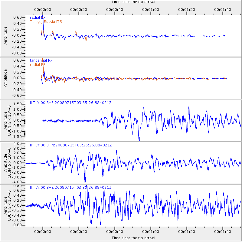
Signal To Noise
| Channel | StoN | STA | LTA |
| II:TLY:00:BHN:20080715T03:35:26.884021Z | 7.04511 | 3.2462776E-7 | 4.6078448E-8 |
| II:TLY:00:BHE:20080715T03:35:26.884021Z | 2.3433723 | 7.281195E-8 | 3.107144E-8 |
| II:TLY:00:BHZ:20080715T03:35:26.884021Z | 4.149172 | 1.6761561E-7 | 4.0397364E-8 |
| Arrivals |
| Ps | 5.5 SECOND |
| PpPs | 15 SECOND |
| PsPs/PpSs | 21 SECOND |


