You are here: Home > Network List > TA - USArray Transportable Network (new EarthScope stations) Stations List
> Station E46A Sault Ste Marie, MI, USA > Earthquake Result Viewer
E46A Sault Ste Marie, MI, USA - Earthquake Result Viewer

| Earthquake location: |
Near Coast Of Venezuela |
| Earthquake latitude/longitude: |
10.9/-62.3 |
| Earthquake time(UTC): |
2013/10/12 (285) 02:10:27 GMT |
| Earthquake Depth: |
63 km |
| Earthquake Magnitude: |
6.0 MWW, 6.0 MWW, 6.0 MWB, 6.0 MWC, 6.0 MI |
| Earthquake Catalog/Contributor: |
NEIC PDE/NEIC COMCAT |
|
| Network: |
TA USArray Transportable Network (new EarthScope stations) |
| Station: |
E46A Sault Ste Marie, MI, USA |
| Lat/Lon: |
46.37 N/84.31 W |
| Elevation: |
269 m |
|
| Distance: |
40.0 deg |
| Az: |
336.2 deg |
| Baz: |
145.083 deg |
| Ray Param: |
0.07448027 |
| Estimated Moho Depth: |
14.5 km |
| Estimated Crust Vp/Vs: |
2.10 |
| Assumed Crust Vp: |
6.467 km/s |
| Estimated Crust Vs: |
3.083 km/s |
| Estimated Crust Poisson's Ratio: |
0.35 |
|
| Radial Match: |
87.17101 % |
| Radial Bump: |
343 |
| Transverse Match: |
57.09376 % |
| Transverse Bump: |
379 |
| SOD ConfigId: |
626651 |
| Insert Time: |
2014-04-19 01:40:20.047 +0000 |
| GWidth: |
2.5 |
| Max Bumps: |
400 |
| Tol: |
0.001 |
|
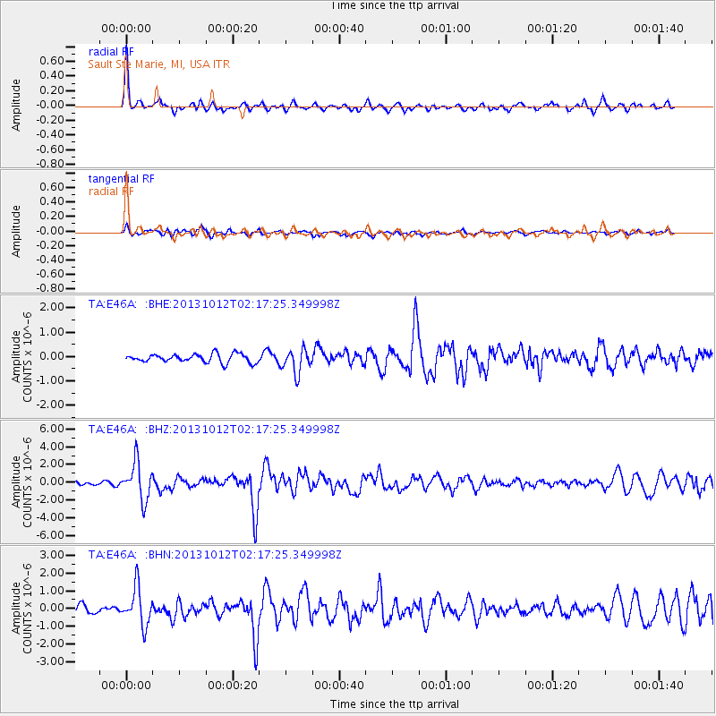
Signal To Noise
| Channel | StoN | STA | LTA |
| TA:E46A: :BHZ:20131012T02:17:25.349998Z | 9.873238 | 2.1036285E-6 | 2.1306369E-7 |
| TA:E46A: :BHN:20131012T02:17:25.349998Z | 4.8277965 | 1.0641446E-6 | 2.2042036E-7 |
| TA:E46A: :BHE:20131012T02:17:25.349998Z | 2.8188295 | 4.863912E-7 | 1.7255076E-7 |
| Arrivals |
| Ps | 2.6 SECOND |
| PpPs | 6.5 SECOND |
| PsPs/PpSs | 9.2 SECOND |


