You are here: Home > Network List > TA - USArray Transportable Network (new EarthScope stations) Stations List
> Station E63A Oxbow, ME, USA > Earthquake Result Viewer
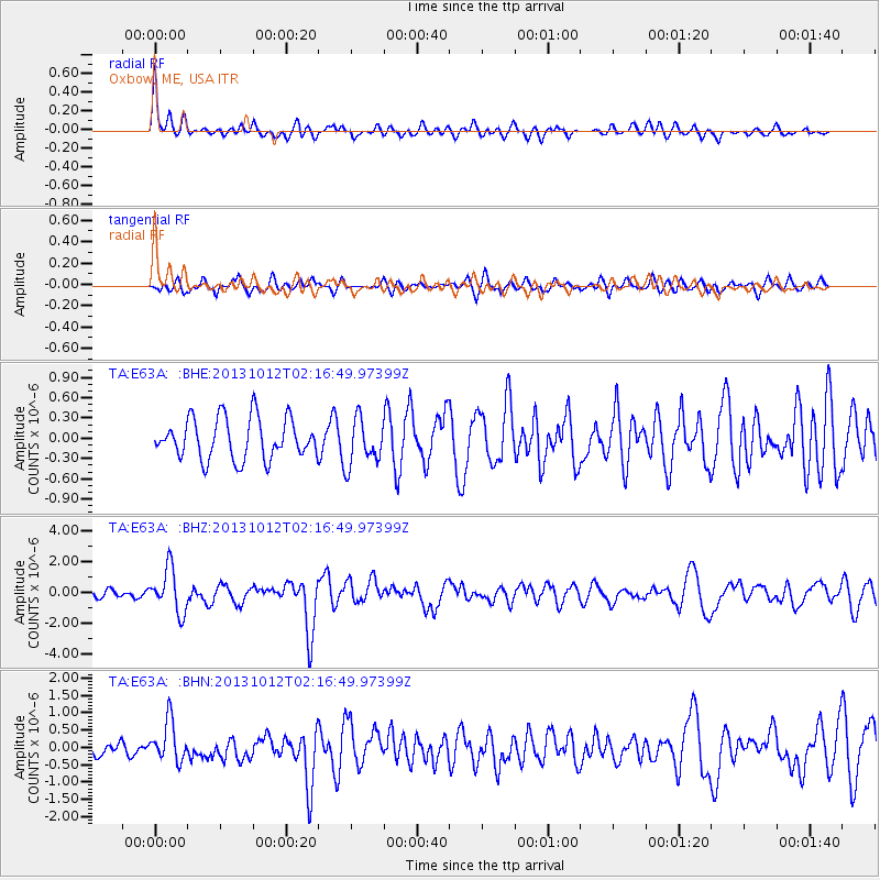
E63A Oxbow, ME, USA - Earthquake Result Viewer
*The percent match for this event was below the threshold and hence no stack was calculated.
| Earthquake location: |
Near Coast Of Venezuela |
| Earthquake latitude/longitude: |
10.9/-62.3 |
| Earthquake time(UTC): |
2013/10/12 (285) 02:10:27 GMT |
| Earthquake Depth: |
63 km |
| Earthquake Magnitude: |
6.0 MWW, 6.0 MWW, 6.0 MWB, 6.0 MWC, 6.0 MI |
| Earthquake Catalog/Contributor: |
NEIC PDE/NEIC COMCAT |
|
| Network: |
TA USArray Transportable Network (new EarthScope stations) |
| Station: |
E63A Oxbow, ME, USA |
| Lat/Lon: |
46.42 N/68.42 W |
| Elevation: |
238 m |
|
| Distance: |
35.8 deg |
| Az: |
352.768 deg |
| Baz: |
169.704 deg |
| Ray Param: |
$rayparam |
*The percent match for this event was below the threshold and hence was not used in the summary stack. |
|
| Radial Match: |
77.08011 % |
| Radial Bump: |
400 |
| Transverse Match: |
56.85217 % |
| Transverse Bump: |
400 |
| SOD ConfigId: |
626651 |
| Insert Time: |
2014-04-19 01:40:59.949 +0000 |
| GWidth: |
2.5 |
| Max Bumps: |
400 |
| Tol: |
0.001 |
|
Signal To Noise
| Channel | StoN | STA | LTA |
| TA:E63A: :BHZ:20131012T02:16:49.97399Z | 8.156088 | 1.4233337E-6 | 1.7451181E-7 |
| TA:E63A: :BHN:20131012T02:16:49.97399Z | 3.8474958 | 5.885232E-7 | 1.5296267E-7 |
| TA:E63A: :BHE:20131012T02:16:49.97399Z | 1.1428213 | 3.4323108E-7 | 3.003366E-7 |
| Arrivals |
| Ps | |
| PpPs | |
| PsPs/PpSs | |


