You are here: Home > Network List > TA - USArray Transportable Network (new EarthScope stations) Stations List
> Station F57A Harrington, QC, CAN > Earthquake Result Viewer
F57A Harrington, QC, CAN - Earthquake Result Viewer
| Earthquake location: |
Near Coast Of Venezuela |
| Earthquake latitude/longitude: |
10.9/-62.3 |
| Earthquake time(UTC): |
2013/10/12 (285) 02:10:27 GMT |
| Earthquake Depth: |
63 km |
| Earthquake Magnitude: |
6.0 MWW, 6.0 MWW, 6.0 MWB, 6.0 MWC, 6.0 MI |
| Earthquake Catalog/Contributor: |
NEIC PDE/NEIC COMCAT |
|
| Network: |
TA USArray Transportable Network (new EarthScope stations) |
| Station: |
F57A Harrington, QC, CAN |
| Lat/Lon: |
45.81 N/74.69 W |
| Elevation: |
178 m |
|
| Distance: |
36.4 deg |
| Az: |
345.351 deg |
| Baz: |
159.199 deg |
| Ray Param: |
0.07654732 |
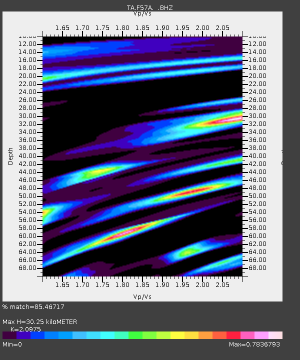
| Estimated Moho Depth: |
30.25 km |
| Estimated Crust Vp/Vs: |
2.10 |
| Assumed Crust Vp: |
6.419 km/s |
| Estimated Crust Vs: |
3.06 km/s |
| Estimated Crust Poisson's Ratio: |
0.35 |
|
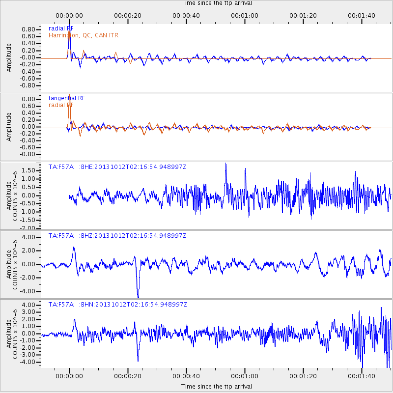
| Radial Match: |
85.46717 % |
| Radial Bump: |
400 |
| Transverse Match: |
55.24394 % |
| Transverse Bump: |
400 |
| SOD ConfigId: |
626651 |
| Insert Time: |
2014-04-19 01:41:31.282 +0000 |
| GWidth: |
2.5 |
| Max Bumps: |
400 |
| Tol: |
0.001 |
|
Signal To Noise
| Channel | StoN | STA | LTA |
| TA:F57A: :BHZ:20131012T02:16:54.948997Z | 6.170742 | 1.0811348E-6 | 1.7520337E-7 |
| TA:F57A: :BHN:20131012T02:16:54.948997Z | 3.4002633 | 7.6161507E-7 | 2.2398707E-7 |
| TA:F57A: :BHE:20131012T02:16:54.948997Z | 1.6634984 | 3.315352E-7 | 1.9929998E-7 |
| Arrivals |
| Ps | 5.5 SECOND |
| PpPs | 14 SECOND |
| PsPs/PpSs | 19 SECOND |


