You are here: Home > Network List > TA - USArray Transportable Network (new EarthScope stations) Stations List
> Station G39A Holcombe, WI, USA > Earthquake Result Viewer
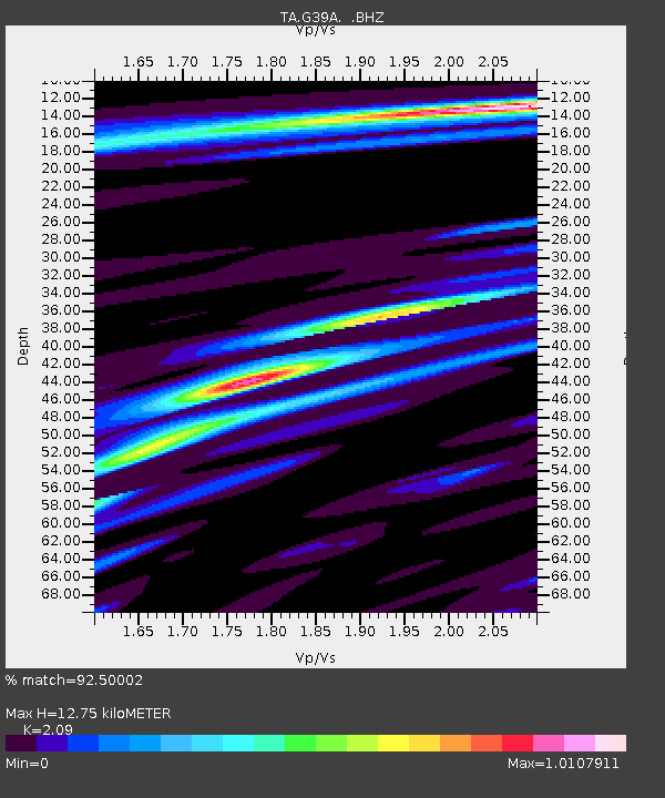
G39A Holcombe, WI, USA - Earthquake Result Viewer
| Earthquake location: |
Near Coast Of Venezuela |
| Earthquake latitude/longitude: |
10.9/-62.3 |
| Earthquake time(UTC): |
2013/10/12 (285) 02:10:27 GMT |
| Earthquake Depth: |
63 km |
| Earthquake Magnitude: |
6.0 MWW, 6.0 MWW, 6.0 MWB, 6.0 MWC, 6.0 MI |
| Earthquake Catalog/Contributor: |
NEIC PDE/NEIC COMCAT |
|
| Network: |
TA USArray Transportable Network (new EarthScope stations) |
| Station: |
G39A Holcombe, WI, USA |
| Lat/Lon: |
45.29 N/91.17 W |
| Elevation: |
350 m |
|
| Distance: |
42.2 deg |
| Az: |
329.546 deg |
| Baz: |
135.157 deg |
| Ray Param: |
0.07311776 |
| Estimated Moho Depth: |
12.75 km |
| Estimated Crust Vp/Vs: |
2.09 |
| Assumed Crust Vp: |
6.571 km/s |
| Estimated Crust Vs: |
3.144 km/s |
| Estimated Crust Poisson's Ratio: |
0.35 |
|
| Radial Match: |
92.50002 % |
| Radial Bump: |
400 |
| Transverse Match: |
75.91151 % |
| Transverse Bump: |
400 |
| SOD ConfigId: |
626651 |
| Insert Time: |
2014-04-19 01:41:59.199 +0000 |
| GWidth: |
2.5 |
| Max Bumps: |
400 |
| Tol: |
0.001 |
|

Signal To Noise
| Channel | StoN | STA | LTA |
| TA:G39A: :BHZ:20131012T02:17:43.80001Z | 14.263131 | 1.973556E-6 | 1.3836765E-7 |
| TA:G39A: :BHN:20131012T02:17:43.80001Z | 6.7877345 | 8.0020595E-7 | 1.1788999E-7 |
| TA:G39A: :BHE:20131012T02:17:43.80001Z | 8.323376 | 9.780689E-7 | 1.1750868E-7 |
| Arrivals |
| Ps | 2.2 SECOND |
| PpPs | 5.6 SECOND |
| PsPs/PpSs | 7.9 SECOND |


