You are here: Home > Network List > TA - USArray Transportable Network (new EarthScope stations) Stations List
> Station G63A Kingsbury, ME, USA > Earthquake Result Viewer
G63A Kingsbury, ME, USA - Earthquake Result Viewer
| Earthquake location: |
Near Coast Of Venezuela |
| Earthquake latitude/longitude: |
10.9/-62.3 |
| Earthquake time(UTC): |
2013/10/12 (285) 02:10:27 GMT |
| Earthquake Depth: |
63 km |
| Earthquake Magnitude: |
6.0 MWW, 6.0 MWW, 6.0 MWB, 6.0 MWC, 6.0 MI |
| Earthquake Catalog/Contributor: |
NEIC PDE/NEIC COMCAT |
|
| Network: |
TA USArray Transportable Network (new EarthScope stations) |
| Station: |
G63A Kingsbury, ME, USA |
| Lat/Lon: |
45.11 N/69.62 W |
| Elevation: |
363 m |
|
| Distance: |
34.7 deg |
| Az: |
350.893 deg |
| Baz: |
167.318 deg |
| Ray Param: |
0.07745584 |
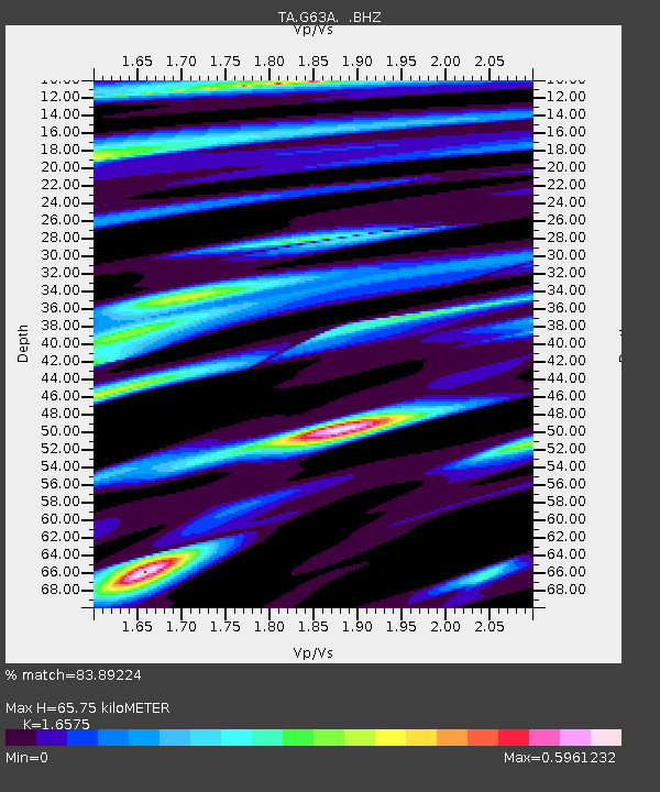
| Estimated Moho Depth: |
65.75 km |
| Estimated Crust Vp/Vs: |
1.66 |
| Assumed Crust Vp: |
6.419 km/s |
| Estimated Crust Vs: |
3.873 km/s |
| Estimated Crust Poisson's Ratio: |
0.21 |
|
| Radial Match: |
83.89224 % |
| Radial Bump: |
299 |
| Transverse Match: |
68.00927 % |
| Transverse Bump: |
400 |
| SOD ConfigId: |
626651 |
| Insert Time: |
2014-04-19 01:42:35.077 +0000 |
| GWidth: |
2.5 |
| Max Bumps: |
400 |
| Tol: |
0.001 |
|
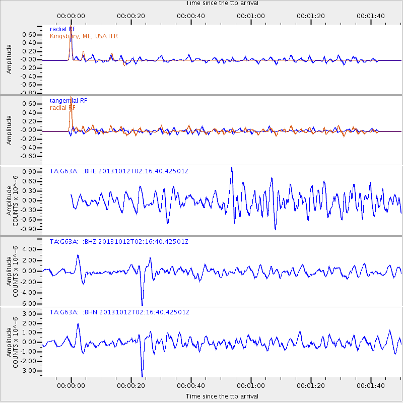
Signal To Noise
| Channel | StoN | STA | LTA |
| TA:G63A: :BHZ:20131012T02:16:40.42501Z | 4.0927563 | 1.4433624E-6 | 3.5266265E-7 |
| TA:G63A: :BHN:20131012T02:16:40.42501Z | 3.6413968 | 8.702239E-7 | 2.3898082E-7 |
| TA:G63A: :BHE:20131012T02:16:40.42501Z | 1.9498487 | 3.4726438E-7 | 1.7809812E-7 |
| Arrivals |
| Ps | 7.3 SECOND |
| PpPs | 25 SECOND |
| PsPs/PpSs | 32 SECOND |


