You are here: Home > Network List > CI - Caltech Regional Seismic Network Stations List
> Station TIN Tinemaha, Big Pine, CA, USA > Earthquake Result Viewer
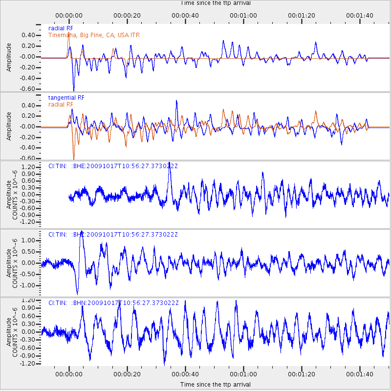
TIN Tinemaha, Big Pine, CA, USA - Earthquake Result Viewer
*The percent match for this event was below the threshold and hence no stack was calculated.
| Earthquake location: |
Samoa Islands Region |
| Earthquake latitude/longitude: |
-16.4/-172.0 |
| Earthquake time(UTC): |
2009/10/17 (290) 10:45:26 GMT |
| Earthquake Depth: |
10 km |
| Earthquake Magnitude: |
5.7 MB, 5.3 MS, 5.7 MW, 5.7 MW |
| Earthquake Catalog/Contributor: |
WHDF/NEIC |
|
| Network: |
CI Caltech Regional Seismic Network |
| Station: |
TIN Tinemaha, Big Pine, CA, USA |
| Lat/Lon: |
37.05 N/118.23 W |
| Elevation: |
1197 m |
|
| Distance: |
73.4 deg |
| Az: |
42.326 deg |
| Baz: |
233.902 deg |
| Ray Param: |
$rayparam |
*The percent match for this event was below the threshold and hence was not used in the summary stack. |
|
| Radial Match: |
75.80423 % |
| Radial Bump: |
400 |
| Transverse Match: |
74.94217 % |
| Transverse Bump: |
400 |
| SOD ConfigId: |
2622 |
| Insert Time: |
2010-02-25 20:52:45.286 +0000 |
| GWidth: |
2.5 |
| Max Bumps: |
400 |
| Tol: |
0.001 |
|
Signal To Noise
| Channel | StoN | STA | LTA |
| CI:TIN: :BHZ:20091017T10:56:27.373022Z | 4.5146346 | 7.5590924E-7 | 1.674353E-7 |
| CI:TIN: :BHN:20091017T10:56:27.373022Z | 2.154633 | 3.3058586E-7 | 1.5343024E-7 |
| CI:TIN: :BHE:20091017T10:56:27.373022Z | 2.8072712 | 5.051725E-7 | 1.7995146E-7 |
| Arrivals |
| Ps | |
| PpPs | |
| PsPs/PpSs | |


