You are here: Home > Network List > TA - USArray Transportable Network (new EarthScope stations) Stations List
> Station H52A Wyevale, ON, CAN > Earthquake Result Viewer
H52A Wyevale, ON, CAN - Earthquake Result Viewer
| Earthquake location: |
Near Coast Of Venezuela |
| Earthquake latitude/longitude: |
10.9/-62.3 |
| Earthquake time(UTC): |
2013/10/12 (285) 02:10:27 GMT |
| Earthquake Depth: |
63 km |
| Earthquake Magnitude: |
6.0 MWW, 6.0 MWW, 6.0 MWB, 6.0 MWC, 6.0 MI |
| Earthquake Catalog/Contributor: |
NEIC PDE/NEIC COMCAT |
|
| Network: |
TA USArray Transportable Network (new EarthScope stations) |
| Station: |
H52A Wyevale, ON, CAN |
| Lat/Lon: |
44.64 N/79.89 W |
| Elevation: |
209 m |
|
| Distance: |
36.9 deg |
| Az: |
338.945 deg |
| Baz: |
150.376 deg |
| Ray Param: |
0.076272115 |
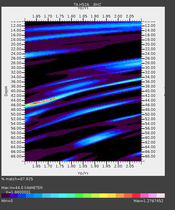
| Estimated Moho Depth: |
44.0 km |
| Estimated Crust Vp/Vs: |
1.68 |
| Assumed Crust Vp: |
6.577 km/s |
| Estimated Crust Vs: |
3.915 km/s |
| Estimated Crust Poisson's Ratio: |
0.23 |
|
| Radial Match: |
87.925 % |
| Radial Bump: |
304 |
| Transverse Match: |
76.61589 % |
| Transverse Bump: |
400 |
| SOD ConfigId: |
626651 |
| Insert Time: |
2014-04-19 01:43:02.742 +0000 |
| GWidth: |
2.5 |
| Max Bumps: |
400 |
| Tol: |
0.001 |
|
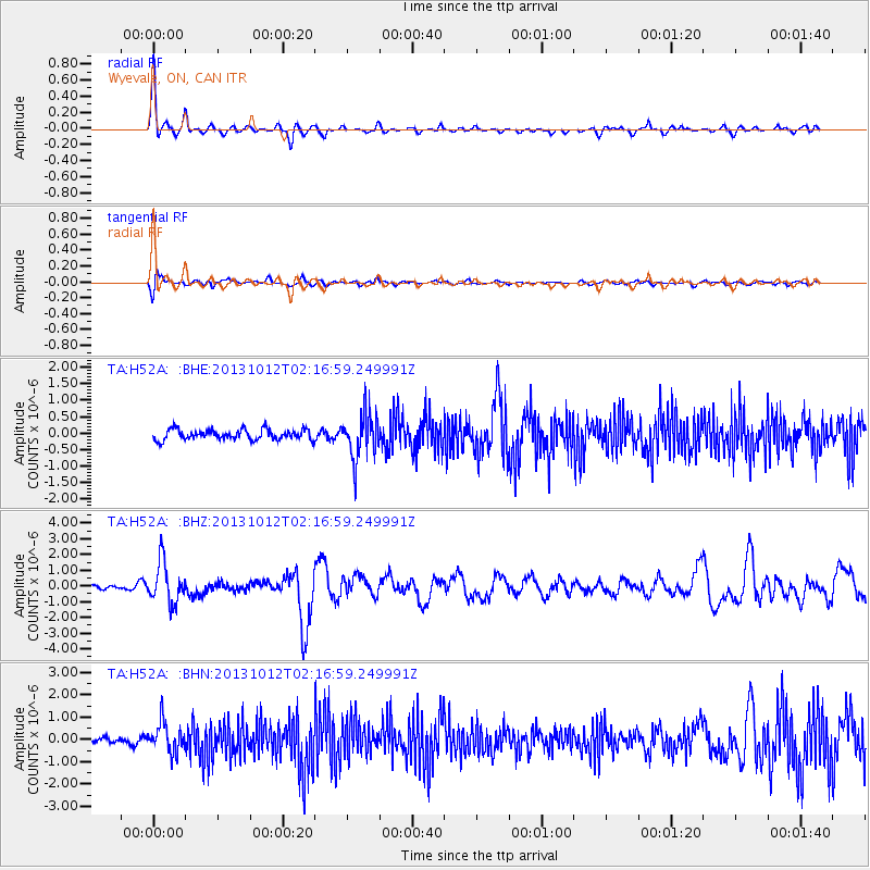
Signal To Noise
| Channel | StoN | STA | LTA |
| TA:H52A: :BHZ:20131012T02:16:59.249991Z | 6.926135 | 1.3173283E-6 | 1.9019673E-7 |
| TA:H52A: :BHN:20131012T02:16:59.249991Z | 3.9146278 | 6.5862554E-7 | 1.682473E-7 |
| TA:H52A: :BHE:20131012T02:16:59.249991Z | 4.406653 | 6.876841E-7 | 1.5605589E-7 |
| Arrivals |
| Ps | 4.9 SECOND |
| PpPs | 17 SECOND |
| PsPs/PpSs | 21 SECOND |


