You are here: Home > Network List > TA - USArray Transportable Network (new EarthScope stations) Stations List
> Station H56A Elgin, ON, CAN > Earthquake Result Viewer
H56A Elgin, ON, CAN - Earthquake Result Viewer
| Earthquake location: |
Near Coast Of Venezuela |
| Earthquake latitude/longitude: |
10.9/-62.3 |
| Earthquake time(UTC): |
2013/10/12 (285) 02:10:27 GMT |
| Earthquake Depth: |
63 km |
| Earthquake Magnitude: |
6.0 MWW, 6.0 MWW, 6.0 MWB, 6.0 MWC, 6.0 MI |
| Earthquake Catalog/Contributor: |
NEIC PDE/NEIC COMCAT |
|
| Network: |
TA USArray Transportable Network (new EarthScope stations) |
| Station: |
H56A Elgin, ON, CAN |
| Lat/Lon: |
44.59 N/76.26 W |
| Elevation: |
137 m |
|
| Distance: |
35.7 deg |
| Az: |
342.82 deg |
| Baz: |
156.042 deg |
| Ray Param: |
0.07693046 |
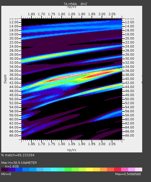
| Estimated Moho Depth: |
38.5 km |
| Estimated Crust Vp/Vs: |
1.84 |
| Assumed Crust Vp: |
6.577 km/s |
| Estimated Crust Vs: |
3.584 km/s |
| Estimated Crust Poisson's Ratio: |
0.29 |
|
| Radial Match: |
85.233284 % |
| Radial Bump: |
225 |
| Transverse Match: |
64.562164 % |
| Transverse Bump: |
400 |
| SOD ConfigId: |
626651 |
| Insert Time: |
2014-04-19 01:43:11.928 +0000 |
| GWidth: |
2.5 |
| Max Bumps: |
400 |
| Tol: |
0.001 |
|

Signal To Noise
| Channel | StoN | STA | LTA |
| TA:H56A: :BHZ:20131012T02:16:48.950004Z | 4.9700727 | 1.0465279E-6 | 2.1056591E-7 |
| TA:H56A: :BHN:20131012T02:16:48.950004Z | 3.625886 | 6.936564E-7 | 1.9130673E-7 |
| TA:H56A: :BHE:20131012T02:16:48.950004Z | 1.9039543 | 2.2029718E-7 | 1.15705085E-7 |
| Arrivals |
| Ps | 5.3 SECOND |
| PpPs | 15 SECOND |
| PsPs/PpSs | 21 SECOND |


