You are here: Home > Network List > TA - USArray Transportable Network (new EarthScope stations) Stations List
> Station H57A Richville, NY, USA > Earthquake Result Viewer
H57A Richville, NY, USA - Earthquake Result Viewer
| Earthquake location: |
Near Coast Of Venezuela |
| Earthquake latitude/longitude: |
10.9/-62.3 |
| Earthquake time(UTC): |
2013/10/12 (285) 02:10:27 GMT |
| Earthquake Depth: |
63 km |
| Earthquake Magnitude: |
6.0 MWW, 6.0 MWW, 6.0 MWB, 6.0 MWC, 6.0 MI |
| Earthquake Catalog/Contributor: |
NEIC PDE/NEIC COMCAT |
|
| Network: |
TA USArray Transportable Network (new EarthScope stations) |
| Station: |
H57A Richville, NY, USA |
| Lat/Lon: |
44.46 N/75.39 W |
| Elevation: |
132 m |
|
| Distance: |
35.3 deg |
| Az: |
343.714 deg |
| Baz: |
157.378 deg |
| Ray Param: |
0.077128105 |
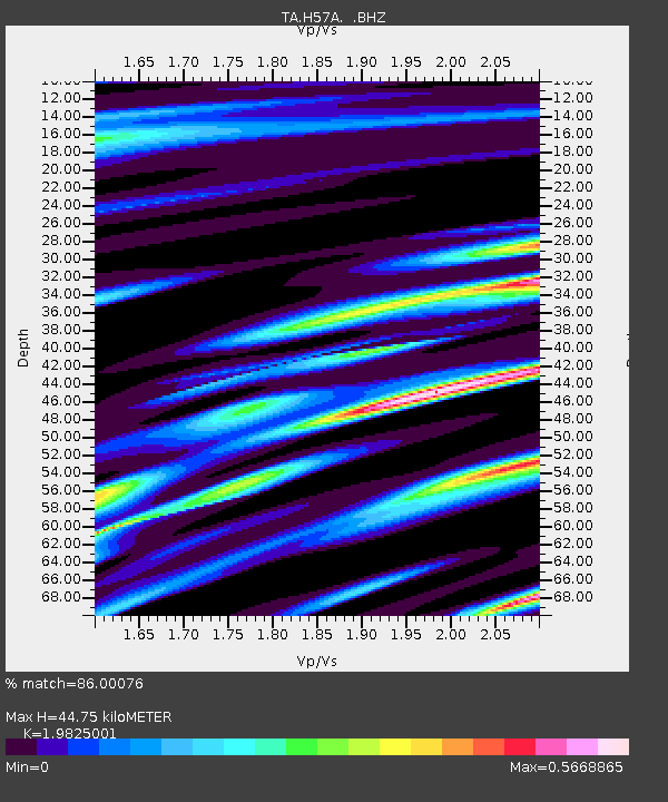
| Estimated Moho Depth: |
44.75 km |
| Estimated Crust Vp/Vs: |
1.98 |
| Assumed Crust Vp: |
6.419 km/s |
| Estimated Crust Vs: |
3.238 km/s |
| Estimated Crust Poisson's Ratio: |
0.33 |
|
| Radial Match: |
86.00076 % |
| Radial Bump: |
347 |
| Transverse Match: |
40.73504 % |
| Transverse Bump: |
400 |
| SOD ConfigId: |
626651 |
| Insert Time: |
2014-04-19 01:43:13.981 +0000 |
| GWidth: |
2.5 |
| Max Bumps: |
400 |
| Tol: |
0.001 |
|
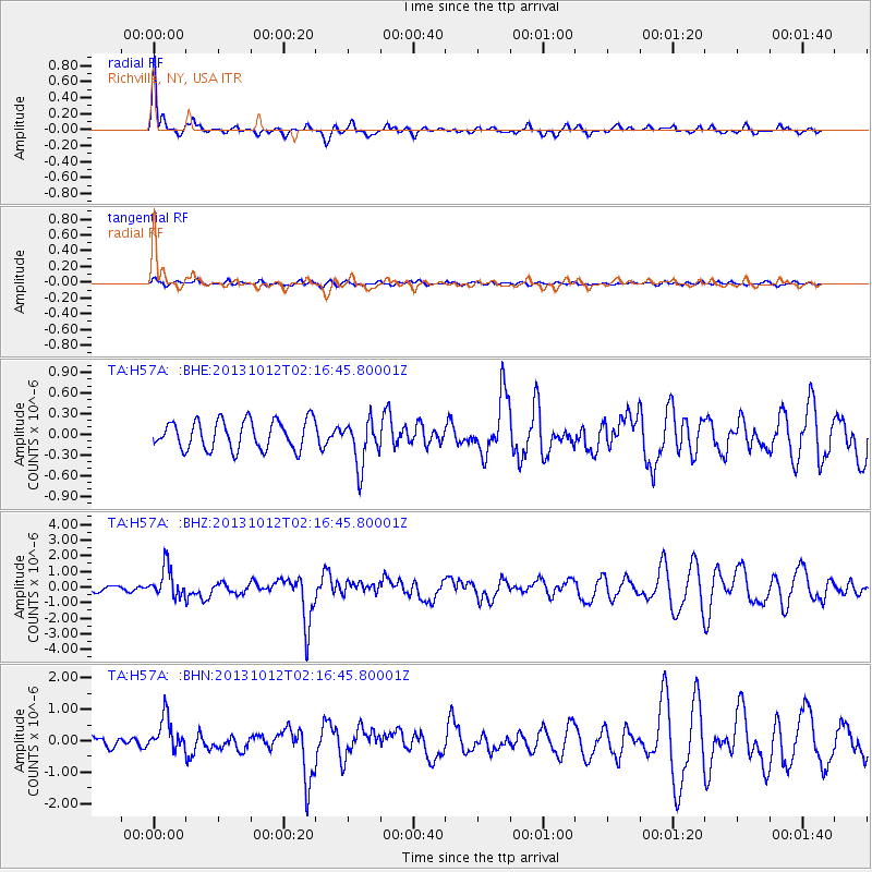
Signal To Noise
| Channel | StoN | STA | LTA |
| TA:H57A: :BHZ:20131012T02:16:45.80001Z | 3.963414 | 9.648177E-7 | 2.4343097E-7 |
| TA:H57A: :BHN:20131012T02:16:45.80001Z | 4.198027 | 5.4756765E-7 | 1.3043451E-7 |
| TA:H57A: :BHE:20131012T02:16:45.80001Z | 1.5922052 | 3.3275694E-7 | 2.0899125E-7 |
| Arrivals |
| Ps | 7.3 SECOND |
| PpPs | 19 SECOND |
| PsPs/PpSs | 27 SECOND |


