You are here: Home > Network List > TA - USArray Transportable Network (new EarthScope stations) Stations List
> Station H62A Milan, NH, USA > Earthquake Result Viewer
H62A Milan, NH, USA - Earthquake Result Viewer
| Earthquake location: |
Near Coast Of Venezuela |
| Earthquake latitude/longitude: |
10.9/-62.3 |
| Earthquake time(UTC): |
2013/10/12 (285) 02:10:27 GMT |
| Earthquake Depth: |
63 km |
| Earthquake Magnitude: |
6.0 MWW, 6.0 MWW, 6.0 MWB, 6.0 MWC, 6.0 MI |
| Earthquake Catalog/Contributor: |
NEIC PDE/NEIC COMCAT |
|
| Network: |
TA USArray Transportable Network (new EarthScope stations) |
| Station: |
H62A Milan, NH, USA |
| Lat/Lon: |
44.57 N/71.16 W |
| Elevation: |
381 m |
|
| Distance: |
34.4 deg |
| Az: |
348.79 deg |
| Baz: |
164.504 deg |
| Ray Param: |
0.077588744 |
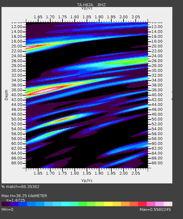
| Estimated Moho Depth: |
38.25 km |
| Estimated Crust Vp/Vs: |
1.67 |
| Assumed Crust Vp: |
6.419 km/s |
| Estimated Crust Vs: |
3.838 km/s |
| Estimated Crust Poisson's Ratio: |
0.22 |
|
| Radial Match: |
88.35382 % |
| Radial Bump: |
255 |
| Transverse Match: |
75.98722 % |
| Transverse Bump: |
364 |
| SOD ConfigId: |
626651 |
| Insert Time: |
2014-04-19 01:43:25.907 +0000 |
| GWidth: |
2.5 |
| Max Bumps: |
400 |
| Tol: |
0.001 |
|

Signal To Noise
| Channel | StoN | STA | LTA |
| TA:H62A: :BHZ:20131012T02:16:38.198997Z | 5.9965835 | 1.5422697E-6 | 2.571914E-7 |
| TA:H62A: :BHN:20131012T02:16:38.198997Z | 4.4637747 | 9.480132E-7 | 2.1237926E-7 |
| TA:H62A: :BHE:20131012T02:16:38.198997Z | 1.1601163 | 1.6290447E-7 | 1.4042081E-7 |
| Arrivals |
| Ps | 4.3 SECOND |
| PpPs | 15 SECOND |
| PsPs/PpSs | 19 SECOND |


