You are here: Home > Network List > TA - USArray Transportable Network (new EarthScope stations) Stations List
> Station I52A Shelburne, ON, CAN > Earthquake Result Viewer
I52A Shelburne, ON, CAN - Earthquake Result Viewer
| Earthquake location: |
Near Coast Of Venezuela |
| Earthquake latitude/longitude: |
10.9/-62.3 |
| Earthquake time(UTC): |
2013/10/12 (285) 02:10:27 GMT |
| Earthquake Depth: |
63 km |
| Earthquake Magnitude: |
6.0 MWW, 6.0 MWW, 6.0 MWB, 6.0 MWC, 6.0 MI |
| Earthquake Catalog/Contributor: |
NEIC PDE/NEIC COMCAT |
|
| Network: |
TA USArray Transportable Network (new EarthScope stations) |
| Station: |
I52A Shelburne, ON, CAN |
| Lat/Lon: |
44.07 N/80.18 W |
| Elevation: |
505 m |
|
| Distance: |
36.5 deg |
| Az: |
338.164 deg |
| Baz: |
149.549 deg |
| Ray Param: |
0.076485746 |
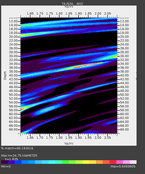
| Estimated Moho Depth: |
34.75 km |
| Estimated Crust Vp/Vs: |
1.93 |
| Assumed Crust Vp: |
6.53 km/s |
| Estimated Crust Vs: |
3.375 km/s |
| Estimated Crust Poisson's Ratio: |
0.32 |
|
| Radial Match: |
88.193016 % |
| Radial Bump: |
400 |
| Transverse Match: |
73.30419 % |
| Transverse Bump: |
400 |
| SOD ConfigId: |
626651 |
| Insert Time: |
2014-04-19 01:44:11.333 +0000 |
| GWidth: |
2.5 |
| Max Bumps: |
400 |
| Tol: |
0.001 |
|

Signal To Noise
| Channel | StoN | STA | LTA |
| TA:I52A: :BHZ:20131012T02:16:55.899985Z | 8.379784 | 1.6428039E-6 | 1.960437E-7 |
| TA:I52A: :BHN:20131012T02:16:55.899985Z | 5.629916 | 1.0220854E-6 | 1.8154542E-7 |
| TA:I52A: :BHE:20131012T02:16:55.899985Z | 3.8194718 | 5.672815E-7 | 1.4852355E-7 |
| Arrivals |
| Ps | 5.3 SECOND |
| PpPs | 15 SECOND |
| PsPs/PpSs | 20 SECOND |


