You are here: Home > Network List > TA - USArray Transportable Network (new EarthScope stations) Stations List
> Station I62A Tamworth, NH, USA > Earthquake Result Viewer
I62A Tamworth, NH, USA - Earthquake Result Viewer
| Earthquake location: |
Near Coast Of Venezuela |
| Earthquake latitude/longitude: |
10.9/-62.3 |
| Earthquake time(UTC): |
2013/10/12 (285) 02:10:27 GMT |
| Earthquake Depth: |
63 km |
| Earthquake Magnitude: |
6.0 MWW, 6.0 MWW, 6.0 MWB, 6.0 MWC, 6.0 MI |
| Earthquake Catalog/Contributor: |
NEIC PDE/NEIC COMCAT |
|
| Network: |
TA USArray Transportable Network (new EarthScope stations) |
| Station: |
I62A Tamworth, NH, USA |
| Lat/Lon: |
43.87 N/71.34 W |
| Elevation: |
264 m |
|
| Distance: |
33.8 deg |
| Az: |
348.228 deg |
| Baz: |
163.914 deg |
| Ray Param: |
0.07790383 |
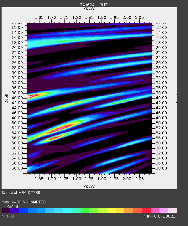
| Estimated Moho Depth: |
39.5 km |
| Estimated Crust Vp/Vs: |
1.60 |
| Assumed Crust Vp: |
6.419 km/s |
| Estimated Crust Vs: |
4.012 km/s |
| Estimated Crust Poisson's Ratio: |
0.18 |
|
| Radial Match: |
86.02789 % |
| Radial Bump: |
400 |
| Transverse Match: |
65.4558 % |
| Transverse Bump: |
400 |
| SOD ConfigId: |
626651 |
| Insert Time: |
2014-04-19 01:44:31.006 +0000 |
| GWidth: |
2.5 |
| Max Bumps: |
400 |
| Tol: |
0.001 |
|

Signal To Noise
| Channel | StoN | STA | LTA |
| TA:I62A: :BHZ:20131012T02:16:32.698997Z | 3.94565 | 1.2410612E-6 | 3.145391E-7 |
| TA:I62A: :BHN:20131012T02:16:32.698997Z | 4.780395 | 8.3610456E-7 | 1.7490282E-7 |
| TA:I62A: :BHE:20131012T02:16:32.698997Z | 1.9664012 | 3.6818827E-7 | 1.8723964E-7 |
| Arrivals |
| Ps | 4.0 SECOND |
| PpPs | 15 SECOND |
| PsPs/PpSs | 19 SECOND |


