You are here: Home > Network List > TA - USArray Transportable Network (new EarthScope stations) Stations List
> Station J47A Sunmer, MI, USA > Earthquake Result Viewer
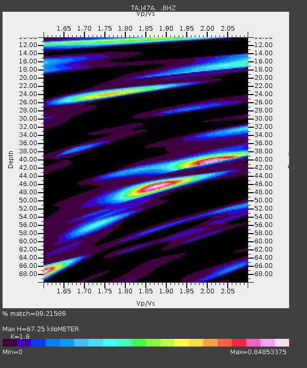
J47A Sunmer, MI, USA - Earthquake Result Viewer
| Earthquake location: |
Near Coast Of Venezuela |
| Earthquake latitude/longitude: |
10.9/-62.3 |
| Earthquake time(UTC): |
2013/10/12 (285) 02:10:27 GMT |
| Earthquake Depth: |
63 km |
| Earthquake Magnitude: |
6.0 MWW, 6.0 MWW, 6.0 MWB, 6.0 MWC, 6.0 MI |
| Earthquake Catalog/Contributor: |
NEIC PDE/NEIC COMCAT |
|
| Network: |
TA USArray Transportable Network (new EarthScope stations) |
| Station: |
J47A Sunmer, MI, USA |
| Lat/Lon: |
43.24 N/84.82 W |
| Elevation: |
236 m |
|
| Distance: |
37.7 deg |
| Az: |
332.766 deg |
| Baz: |
142.046 deg |
| Ray Param: |
0.075814 |
| Estimated Moho Depth: |
67.25 km |
| Estimated Crust Vp/Vs: |
1.60 |
| Assumed Crust Vp: |
6.483 km/s |
| Estimated Crust Vs: |
4.052 km/s |
| Estimated Crust Poisson's Ratio: |
0.18 |
|
| Radial Match: |
89.21589 % |
| Radial Bump: |
400 |
| Transverse Match: |
73.267555 % |
| Transverse Bump: |
400 |
| SOD ConfigId: |
626651 |
| Insert Time: |
2014-04-19 01:44:55.008 +0000 |
| GWidth: |
2.5 |
| Max Bumps: |
400 |
| Tol: |
0.001 |
|

Signal To Noise
| Channel | StoN | STA | LTA |
| TA:J47A: :BHZ:20131012T02:17:06.149985Z | 13.649799 | 2.5231807E-6 | 1.8485112E-7 |
| TA:J47A: :BHN:20131012T02:17:06.149985Z | 7.02171 | 1.2295533E-6 | 1.7510739E-7 |
| TA:J47A: :BHE:20131012T02:17:06.149985Z | 4.8139935 | 1.0041838E-6 | 2.0859684E-7 |
| Arrivals |
| Ps | 6.8 SECOND |
| PpPs | 25 SECOND |
| PsPs/PpSs | 32 SECOND |


