You are here: Home > Network List > TA - USArray Transportable Network (new EarthScope stations) Stations List
> Station J59A Piesco, NY, USA > Earthquake Result Viewer
J59A Piesco, NY, USA - Earthquake Result Viewer
| Earthquake location: |
Near Coast Of Venezuela |
| Earthquake latitude/longitude: |
10.9/-62.3 |
| Earthquake time(UTC): |
2013/10/12 (285) 02:10:27 GMT |
| Earthquake Depth: |
63 km |
| Earthquake Magnitude: |
6.0 MWW, 6.0 MWW, 6.0 MWB, 6.0 MWC, 6.0 MI |
| Earthquake Catalog/Contributor: |
NEIC PDE/NEIC COMCAT |
|
| Network: |
TA USArray Transportable Network (new EarthScope stations) |
| Station: |
J59A Piesco, NY, USA |
| Lat/Lon: |
43.46 N/74.50 W |
| Elevation: |
541 m |
|
| Distance: |
34.1 deg |
| Az: |
344.095 deg |
| Baz: |
158.304 deg |
| Ray Param: |
0.077733554 |
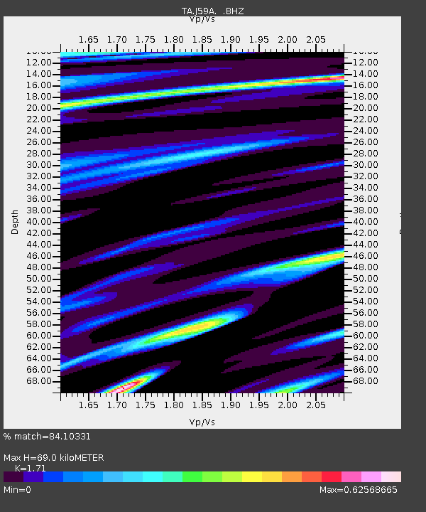
| Estimated Moho Depth: |
69.0 km |
| Estimated Crust Vp/Vs: |
1.71 |
| Assumed Crust Vp: |
6.419 km/s |
| Estimated Crust Vs: |
3.754 km/s |
| Estimated Crust Poisson's Ratio: |
0.24 |
|
| Radial Match: |
84.10331 % |
| Radial Bump: |
346 |
| Transverse Match: |
63.895195 % |
| Transverse Bump: |
400 |
| SOD ConfigId: |
626651 |
| Insert Time: |
2014-04-19 01:45:16.931 +0000 |
| GWidth: |
2.5 |
| Max Bumps: |
400 |
| Tol: |
0.001 |
|

Signal To Noise
| Channel | StoN | STA | LTA |
| TA:J59A: :BHZ:20131012T02:16:35.774985Z | 7.7834625 | 1.3333846E-6 | 1.7130996E-7 |
| TA:J59A: :BHN:20131012T02:16:35.774985Z | 5.4687905 | 5.3943427E-7 | 9.863868E-8 |
| TA:J59A: :BHE:20131012T02:16:35.774985Z | 2.9161298 | 4.1232076E-7 | 1.4139314E-7 |
| Arrivals |
| Ps | 8.3 SECOND |
| PpPs | 27 SECOND |
| PsPs/PpSs | 35 SECOND |


