You are here: Home > Network List > TA - USArray Transportable Network (new EarthScope stations) Stations List
> Station K46A Dorr, MI, USA > Earthquake Result Viewer
K46A Dorr, MI, USA - Earthquake Result Viewer
| Earthquake location: |
Near Coast Of Venezuela |
| Earthquake latitude/longitude: |
10.9/-62.3 |
| Earthquake time(UTC): |
2013/10/12 (285) 02:10:27 GMT |
| Earthquake Depth: |
63 km |
| Earthquake Magnitude: |
6.0 MWW, 6.0 MWW, 6.0 MWB, 6.0 MWC, 6.0 MI |
| Earthquake Catalog/Contributor: |
NEIC PDE/NEIC COMCAT |
|
| Network: |
TA USArray Transportable Network (new EarthScope stations) |
| Station: |
K46A Dorr, MI, USA |
| Lat/Lon: |
42.69 N/85.78 W |
| Elevation: |
213 m |
|
| Distance: |
37.7 deg |
| Az: |
331.301 deg |
| Baz: |
140.233 deg |
| Ray Param: |
0.0758061 |
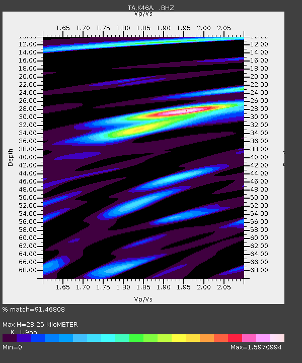
| Estimated Moho Depth: |
28.25 km |
| Estimated Crust Vp/Vs: |
1.96 |
| Assumed Crust Vp: |
6.483 km/s |
| Estimated Crust Vs: |
3.316 km/s |
| Estimated Crust Poisson's Ratio: |
0.32 |
|
| Radial Match: |
91.46808 % |
| Radial Bump: |
354 |
| Transverse Match: |
70.957855 % |
| Transverse Bump: |
400 |
| SOD ConfigId: |
626651 |
| Insert Time: |
2014-04-19 01:45:45.560 +0000 |
| GWidth: |
2.5 |
| Max Bumps: |
400 |
| Tol: |
0.001 |
|

Signal To Noise
| Channel | StoN | STA | LTA |
| TA:K46A: :BHZ:20131012T02:17:06.274985Z | 12.026356 | 2.784144E-6 | 2.3150353E-7 |
| TA:K46A: :BHN:20131012T02:17:06.274985Z | 12.048027 | 1.7882459E-6 | 1.4842644E-7 |
| TA:K46A: :BHE:20131012T02:17:06.274985Z | 7.0235205 | 1.4927728E-6 | 2.125391E-7 |
| Arrivals |
| Ps | 4.5 SECOND |
| PpPs | 12 SECOND |
| PsPs/PpSs | 16 SECOND |


