You are here: Home > Network List > TA - USArray Transportable Network (new EarthScope stations) Stations List
> Station K50A Casco, MI, USA > Earthquake Result Viewer
K50A Casco, MI, USA - Earthquake Result Viewer
| Earthquake location: |
Near Coast Of Venezuela |
| Earthquake latitude/longitude: |
10.9/-62.3 |
| Earthquake time(UTC): |
2013/10/12 (285) 02:10:27 GMT |
| Earthquake Depth: |
63 km |
| Earthquake Magnitude: |
6.0 MWW, 6.0 MWW, 6.0 MWB, 6.0 MWC, 6.0 MI |
| Earthquake Catalog/Contributor: |
NEIC PDE/NEIC COMCAT |
|
| Network: |
TA USArray Transportable Network (new EarthScope stations) |
| Station: |
K50A Casco, MI, USA |
| Lat/Lon: |
42.77 N/82.62 W |
| Elevation: |
191 m |
|
| Distance: |
36.4 deg |
| Az: |
334.46 deg |
| Baz: |
144.893 deg |
| Ray Param: |
0.07655182 |
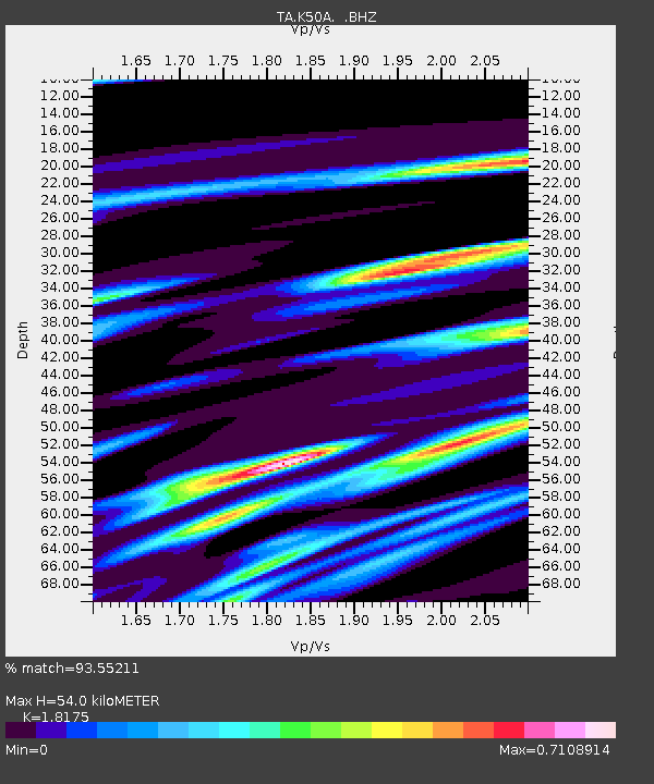
| Estimated Moho Depth: |
54.0 km |
| Estimated Crust Vp/Vs: |
1.82 |
| Assumed Crust Vp: |
6.483 km/s |
| Estimated Crust Vs: |
3.567 km/s |
| Estimated Crust Poisson's Ratio: |
0.28 |
|
| Radial Match: |
93.55211 % |
| Radial Bump: |
254 |
| Transverse Match: |
75.76491 % |
| Transverse Bump: |
400 |
| SOD ConfigId: |
626651 |
| Insert Time: |
2014-04-19 01:45:55.186 +0000 |
| GWidth: |
2.5 |
| Max Bumps: |
400 |
| Tol: |
0.001 |
|

Signal To Noise
| Channel | StoN | STA | LTA |
| TA:K50A: :BHZ:20131012T02:16:54.874991Z | 12.7586975 | 2.0763773E-6 | 1.6274211E-7 |
| TA:K50A: :BHN:20131012T02:16:54.874991Z | 4.051341 | 1.142445E-6 | 2.819918E-7 |
| TA:K50A: :BHE:20131012T02:16:54.874991Z | 4.471758 | 1.1697588E-6 | 2.6158813E-7 |
| Arrivals |
| Ps | 7.3 SECOND |
| PpPs | 22 SECOND |
| PsPs/PpSs | 29 SECOND |


