You are here: Home > Network List > TA - USArray Transportable Network (new EarthScope stations) Stations List
> Station K51A Iona Station, ON, CAN > Earthquake Result Viewer
K51A Iona Station, ON, CAN - Earthquake Result Viewer
| Earthquake location: |
Near Coast Of Venezuela |
| Earthquake latitude/longitude: |
10.9/-62.3 |
| Earthquake time(UTC): |
2013/10/12 (285) 02:10:27 GMT |
| Earthquake Depth: |
63 km |
| Earthquake Magnitude: |
6.0 MWW, 6.0 MWW, 6.0 MWB, 6.0 MWC, 6.0 MI |
| Earthquake Catalog/Contributor: |
NEIC PDE/NEIC COMCAT |
|
| Network: |
TA USArray Transportable Network (new EarthScope stations) |
| Station: |
K51A Iona Station, ON, CAN |
| Lat/Lon: |
42.72 N/81.51 W |
| Elevation: |
217 m |
|
| Distance: |
35.8 deg |
| Az: |
335.562 deg |
| Baz: |
146.537 deg |
| Ray Param: |
0.07682655 |
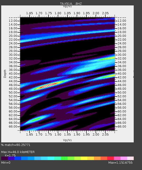
| Estimated Moho Depth: |
46.0 km |
| Estimated Crust Vp/Vs: |
1.75 |
| Assumed Crust Vp: |
6.53 km/s |
| Estimated Crust Vs: |
3.732 km/s |
| Estimated Crust Poisson's Ratio: |
0.26 |
|
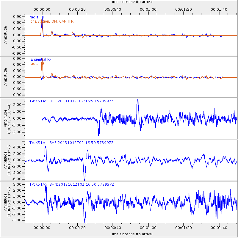
| Radial Match: |
90.25771 % |
| Radial Bump: |
296 |
| Transverse Match: |
65.45754 % |
| Transverse Bump: |
400 |
| SOD ConfigId: |
626651 |
| Insert Time: |
2014-04-19 01:45:57.927 +0000 |
| GWidth: |
2.5 |
| Max Bumps: |
400 |
| Tol: |
0.001 |
|
Signal To Noise
| Channel | StoN | STA | LTA |
| TA:K51A: :BHZ:20131012T02:16:50.573997Z | 12.13641 | 1.9829906E-6 | 1.6339187E-7 |
| TA:K51A: :BHN:20131012T02:16:50.573997Z | 4.254946 | 1.0839112E-6 | 2.5474145E-7 |
| TA:K51A: :BHE:20131012T02:16:50.573997Z | 5.8146005 | 9.197062E-7 | 1.5817187E-7 |
| Arrivals |
| Ps | 5.7 SECOND |
| PpPs | 18 SECOND |
| PsPs/PpSs | 24 SECOND |


