You are here: Home > Network List > TA - USArray Transportable Network (new EarthScope stations) Stations List
> Station K55A Perry, NY, USA > Earthquake Result Viewer
K55A Perry, NY, USA - Earthquake Result Viewer
| Earthquake location: |
Near Coast Of Venezuela |
| Earthquake latitude/longitude: |
10.9/-62.3 |
| Earthquake time(UTC): |
2013/10/12 (285) 02:10:27 GMT |
| Earthquake Depth: |
63 km |
| Earthquake Magnitude: |
6.0 MWW, 6.0 MWW, 6.0 MWB, 6.0 MWC, 6.0 MI |
| Earthquake Catalog/Contributor: |
NEIC PDE/NEIC COMCAT |
|
| Network: |
TA USArray Transportable Network (new EarthScope stations) |
| Station: |
K55A Perry, NY, USA |
| Lat/Lon: |
42.73 N/78.07 W |
| Elevation: |
482 m |
|
| Distance: |
34.6 deg |
| Az: |
339.344 deg |
| Baz: |
151.953 deg |
| Ray Param: |
0.0775116 |
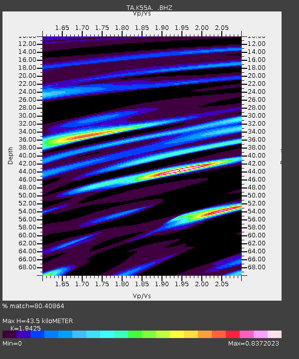
| Estimated Moho Depth: |
43.5 km |
| Estimated Crust Vp/Vs: |
1.94 |
| Assumed Crust Vp: |
6.419 km/s |
| Estimated Crust Vs: |
3.305 km/s |
| Estimated Crust Poisson's Ratio: |
0.32 |
|
| Radial Match: |
80.40864 % |
| Radial Bump: |
361 |
| Transverse Match: |
50.146492 % |
| Transverse Bump: |
400 |
| SOD ConfigId: |
626651 |
| Insert Time: |
2014-04-19 01:46:06.906 +0000 |
| GWidth: |
2.5 |
| Max Bumps: |
400 |
| Tol: |
0.001 |
|

Signal To Noise
| Channel | StoN | STA | LTA |
| TA:K55A: :BHZ:20131012T02:16:39.499015Z | 8.719328 | 1.5715915E-6 | 1.8024228E-7 |
| TA:K55A: :BHN:20131012T02:16:39.499015Z | 4.4265904 | 8.6476166E-7 | 1.9535615E-7 |
| TA:K55A: :BHE:20131012T02:16:39.499015Z | 3.0382123 | 5.312412E-7 | 1.7485321E-7 |
| Arrivals |
| Ps | 6.8 SECOND |
| PpPs | 19 SECOND |
| PsPs/PpSs | 25 SECOND |


