You are here: Home > Network List > TA - USArray Transportable Network (new EarthScope stations) Stations List
> Station K59A Cooperstown, NY, USA > Earthquake Result Viewer
K59A Cooperstown, NY, USA - Earthquake Result Viewer
| Earthquake location: |
Near Coast Of Venezuela |
| Earthquake latitude/longitude: |
10.9/-62.3 |
| Earthquake time(UTC): |
2013/10/12 (285) 02:10:27 GMT |
| Earthquake Depth: |
63 km |
| Earthquake Magnitude: |
6.0 MWW, 6.0 MWW, 6.0 MWB, 6.0 MWC, 6.0 MI |
| Earthquake Catalog/Contributor: |
NEIC PDE/NEIC COMCAT |
|
| Network: |
TA USArray Transportable Network (new EarthScope stations) |
| Station: |
K59A Cooperstown, NY, USA |
| Lat/Lon: |
42.78 N/74.85 W |
| Elevation: |
570 m |
|
| Distance: |
33.6 deg |
| Az: |
343.203 deg |
| Baz: |
157.327 deg |
| Ray Param: |
0.07798867 |
| Estimated Moho Depth: |
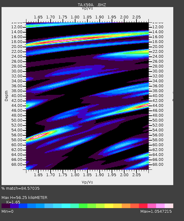
56.25 km |
| Estimated Crust Vp/Vs: |
1.65 |
| Assumed Crust Vp: |
6.419 km/s |
| Estimated Crust Vs: |
3.89 km/s |
| Estimated Crust Poisson's Ratio: |
0.21 |
|
| Radial Match: |
84.57035 % |
| Radial Bump: |
303 |
| Transverse Match: |
64.24809 % |
| Transverse Bump: |
400 |
| SOD ConfigId: |
626651 |
| Insert Time: |
2014-04-19 01:46:17.797 +0000 |
| GWidth: |
2.5 |
| Max Bumps: |
400 |
| Tol: |
0.001 |
|

Signal To Noise
| Channel | StoN | STA | LTA |
| TA:K59A: :BHZ:20131012T02:16:31.09899Z | 4.9603963 | 1.5129401E-6 | 3.0500388E-7 |
| TA:K59A: :BHN:20131012T02:16:31.09899Z | 5.9065933 | 1.0246019E-6 | 1.734675E-7 |
| TA:K59A: :BHE:20131012T02:16:31.09899Z | 2.173737 | 4.364719E-7 | 2.0079332E-7 |
| Arrivals |
| Ps | 6.2 SECOND |
| PpPs | 21 SECOND |
| PsPs/PpSs | 28 SECOND |


