You are here: Home > Network List > TA - USArray Transportable Network (new EarthScope stations) Stations List
> Station L58A Harry Jones Memorial, Binghamton, NY, USA > Earthquake Result Viewer
L58A Harry Jones Memorial, Binghamton, NY, USA - Earthquake Result Viewer

| Earthquake location: |
Near Coast Of Venezuela |
| Earthquake latitude/longitude: |
10.9/-62.3 |
| Earthquake time(UTC): |
2013/10/12 (285) 02:10:27 GMT |
| Earthquake Depth: |
63 km |
| Earthquake Magnitude: |
6.0 MWW, 6.0 MWW, 6.0 MWB, 6.0 MWC, 6.0 MI |
| Earthquake Catalog/Contributor: |
NEIC PDE/NEIC COMCAT |
|
| Network: |
TA USArray Transportable Network (new EarthScope stations) |
| Station: |
L58A Harry Jones Memorial, Binghamton, NY, USA |
| Lat/Lon: |
42.04 N/75.85 W |
| Elevation: |
447 m |
|
| Distance: |
33.2 deg |
| Az: |
341.441 deg |
| Baz: |
155.184 deg |
| Ray Param: |
0.07815878 |
| Estimated Moho Depth: |
66.0 km |
| Estimated Crust Vp/Vs: |
2.05 |
| Assumed Crust Vp: |
6.419 km/s |
| Estimated Crust Vs: |
3.131 km/s |
| Estimated Crust Poisson's Ratio: |
0.34 |
|
| Radial Match: |
86.27871 % |
| Radial Bump: |
299 |
| Transverse Match: |
59.885796 % |
| Transverse Bump: |
400 |
| SOD ConfigId: |
626651 |
| Insert Time: |
2014-04-19 01:47:08.332 +0000 |
| GWidth: |
2.5 |
| Max Bumps: |
400 |
| Tol: |
0.001 |
|
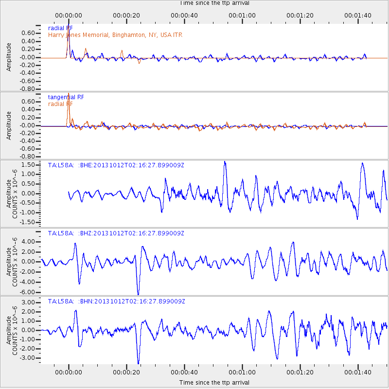
Signal To Noise
| Channel | StoN | STA | LTA |
| TA:L58A: :BHZ:20131012T02:16:27.899009Z | 5.297162 | 2.0028262E-6 | 3.780942E-7 |
| TA:L58A: :BHN:20131012T02:16:27.899009Z | 5.9346247 | 1.1306159E-6 | 1.9051178E-7 |
| TA:L58A: :BHE:20131012T02:16:27.899009Z | 2.8000271 | 4.1110616E-7 | 1.468222E-7 |
| Arrivals |
| Ps | 12 SECOND |
| PpPs | 29 SECOND |
| PsPs/PpSs | 41 SECOND |


