You are here: Home > Network List > TA - USArray Transportable Network (new EarthScope stations) Stations List
> Station L60A Shokan, NY, USA > Earthquake Result Viewer
L60A Shokan, NY, USA - Earthquake Result Viewer

| Earthquake location: |
Near Coast Of Venezuela |
| Earthquake latitude/longitude: |
10.9/-62.3 |
| Earthquake time(UTC): |
2013/10/12 (285) 02:10:27 GMT |
| Earthquake Depth: |
63 km |
| Earthquake Magnitude: |
6.0 MWW, 6.0 MWW, 6.0 MWB, 6.0 MWC, 6.0 MI |
| Earthquake Catalog/Contributor: |
NEIC PDE/NEIC COMCAT |
|
| Network: |
TA USArray Transportable Network (new EarthScope stations) |
| Station: |
L60A Shokan, NY, USA |
| Lat/Lon: |
41.99 N/74.22 W |
| Elevation: |
388 m |
|
| Distance: |
32.7 deg |
| Az: |
343.446 deg |
| Baz: |
157.953 deg |
| Ray Param: |
0.07840442 |
| Estimated Moho Depth: |
52.5 km |
| Estimated Crust Vp/Vs: |
1.68 |
| Assumed Crust Vp: |
6.283 km/s |
| Estimated Crust Vs: |
3.751 km/s |
| Estimated Crust Poisson's Ratio: |
0.22 |
|
| Radial Match: |
80.211555 % |
| Radial Bump: |
400 |
| Transverse Match: |
65.00805 % |
| Transverse Bump: |
349 |
| SOD ConfigId: |
626651 |
| Insert Time: |
2014-04-19 01:47:13.499 +0000 |
| GWidth: |
2.5 |
| Max Bumps: |
400 |
| Tol: |
0.001 |
|
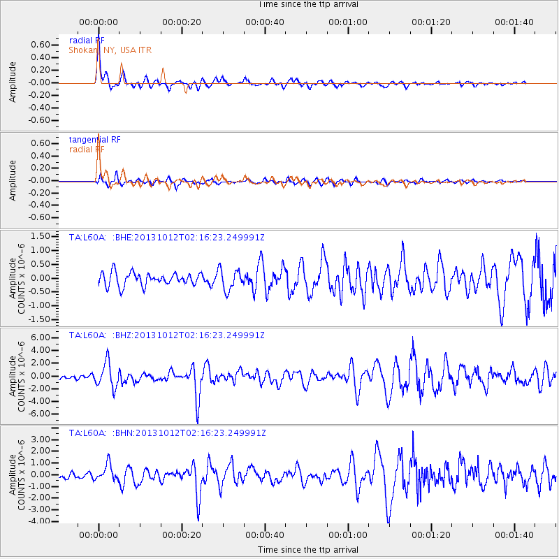
Signal To Noise
| Channel | StoN | STA | LTA |
| TA:L60A: :BHZ:20131012T02:16:23.249991Z | 4.8378143 | 2.0071618E-6 | 4.1489022E-7 |
| TA:L60A: :BHN:20131012T02:16:23.249991Z | 2.6154637 | 7.189525E-7 | 2.7488528E-7 |
| TA:L60A: :BHE:20131012T02:16:23.249991Z | 1.6371675 | 3.79378E-7 | 2.317283E-7 |
| Arrivals |
| Ps | 6.1 SECOND |
| PpPs | 21 SECOND |
| PsPs/PpSs | 27 SECOND |


