You are here: Home > Network List > TA - USArray Transportable Network (new EarthScope stations) Stations List
> Station L63A North Scituate, RI, USA > Earthquake Result Viewer
L63A North Scituate, RI, USA - Earthquake Result Viewer
| Earthquake location: |
Near Coast Of Venezuela |
| Earthquake latitude/longitude: |
10.9/-62.3 |
| Earthquake time(UTC): |
2013/10/12 (285) 02:10:27 GMT |
| Earthquake Depth: |
63 km |
| Earthquake Magnitude: |
6.0 MWW, 6.0 MWW, 6.0 MWB, 6.0 MWC, 6.0 MI |
| Earthquake Catalog/Contributor: |
NEIC PDE/NEIC COMCAT |
|
| Network: |
TA USArray Transportable Network (new EarthScope stations) |
| Station: |
L63A North Scituate, RI, USA |
| Lat/Lon: |
41.86 N/71.61 W |
| Elevation: |
109 m |
|
| Distance: |
31.9 deg |
| Az: |
346.803 deg |
| Baz: |
162.53 deg |
| Ray Param: |
0.07873744 |
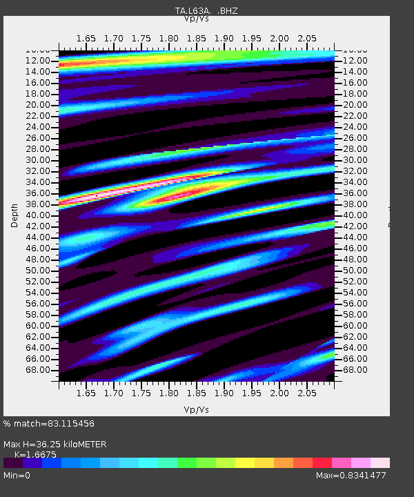
| Estimated Moho Depth: |
36.25 km |
| Estimated Crust Vp/Vs: |
1.67 |
| Assumed Crust Vp: |
6.472 km/s |
| Estimated Crust Vs: |
3.881 km/s |
| Estimated Crust Poisson's Ratio: |
0.22 |
|
| Radial Match: |
83.115456 % |
| Radial Bump: |
356 |
| Transverse Match: |
57.196995 % |
| Transverse Bump: |
400 |
| SOD ConfigId: |
626651 |
| Insert Time: |
2014-04-19 01:47:24.529 +0000 |
| GWidth: |
2.5 |
| Max Bumps: |
400 |
| Tol: |
0.001 |
|

Signal To Noise
| Channel | StoN | STA | LTA |
| TA:L63A: :BHZ:20131012T02:16:16.450004Z | 4.0829806 | 1.0727384E-6 | 2.6273412E-7 |
| TA:L63A: :BHN:20131012T02:16:16.450004Z | 2.7816133 | 6.67021E-7 | 2.3979646E-7 |
| TA:L63A: :BHE:20131012T02:16:16.450004Z | 1.9892578 | 3.672115E-7 | 1.8459724E-7 |
| Arrivals |
| Ps | 4.1 SECOND |
| PpPs | 14 SECOND |
| PsPs/PpSs | 18 SECOND |


