You are here: Home > Network List > TA - USArray Transportable Network (new EarthScope stations) Stations List
> Station M54A Oil Creek State Park, Oil City, PA, USA > Earthquake Result Viewer
M54A Oil Creek State Park, Oil City, PA, USA - Earthquake Result Viewer
| Earthquake location: |
Near Coast Of Venezuela |
| Earthquake latitude/longitude: |
10.9/-62.3 |
| Earthquake time(UTC): |
2013/10/12 (285) 02:10:27 GMT |
| Earthquake Depth: |
63 km |
| Earthquake Magnitude: |
6.0 MWW, 6.0 MWW, 6.0 MWB, 6.0 MWC, 6.0 MI |
| Earthquake Catalog/Contributor: |
NEIC PDE/NEIC COMCAT |
|
| Network: |
TA USArray Transportable Network (new EarthScope stations) |
| Station: |
M54A Oil Creek State Park, Oil City, PA, USA |
| Lat/Lon: |
41.51 N/79.66 W |
| Elevation: |
488 m |
|
| Distance: |
34.1 deg |
| Az: |
336.444 deg |
| Baz: |
148.491 deg |
| Ray Param: |
0.07775315 |
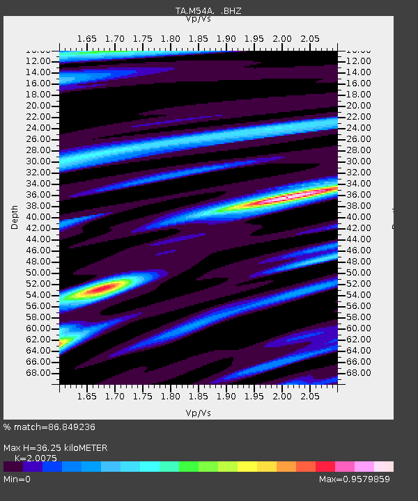
| Estimated Moho Depth: |
36.25 km |
| Estimated Crust Vp/Vs: |
2.01 |
| Assumed Crust Vp: |
6.121 km/s |
| Estimated Crust Vs: |
3.049 km/s |
| Estimated Crust Poisson's Ratio: |
0.33 |
|
| Radial Match: |
86.849236 % |
| Radial Bump: |
303 |
| Transverse Match: |
62.129288 % |
| Transverse Bump: |
400 |
| SOD ConfigId: |
626651 |
| Insert Time: |
2014-04-19 01:48:00.731 +0000 |
| GWidth: |
2.5 |
| Max Bumps: |
400 |
| Tol: |
0.001 |
|
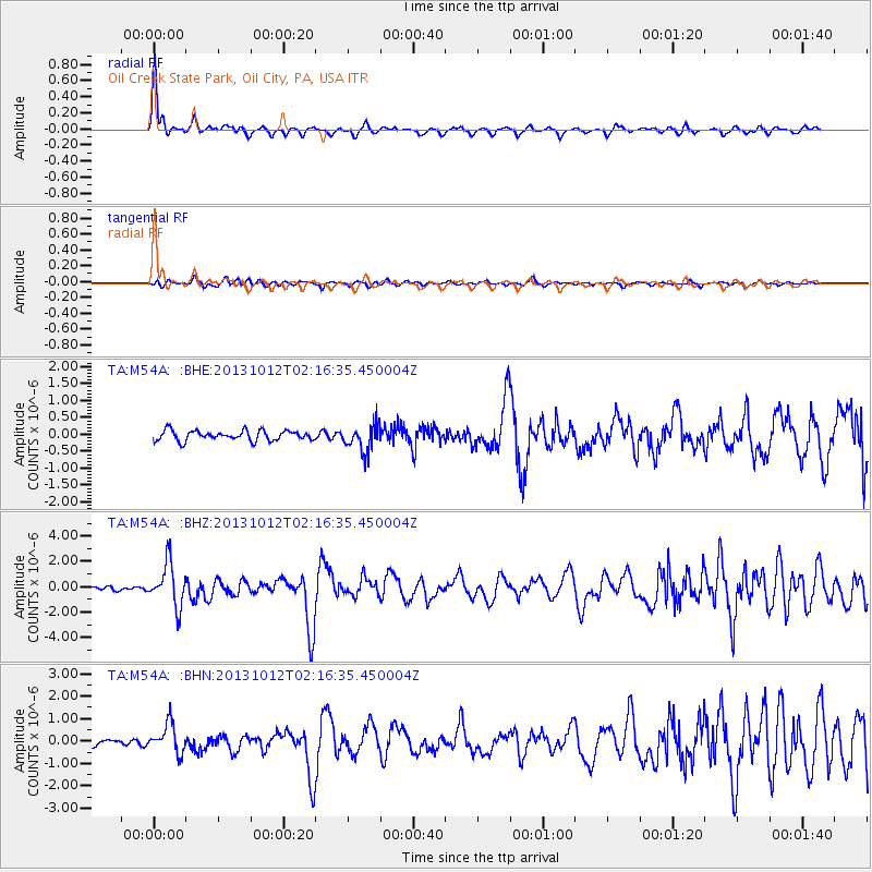
Signal To Noise
| Channel | StoN | STA | LTA |
| TA:M54A: :BHZ:20131012T02:16:35.450004Z | 7.6717815 | 1.7028506E-6 | 2.2196286E-7 |
| TA:M54A: :BHN:20131012T02:16:35.450004Z | 4.5483556 | 6.59333E-7 | 1.4496075E-7 |
| TA:M54A: :BHE:20131012T02:16:35.450004Z | 2.6803524 | 3.949203E-7 | 1.4733895E-7 |
| Arrivals |
| Ps | 6.3 SECOND |
| PpPs | 17 SECOND |
| PsPs/PpSs | 23 SECOND |


