You are here: Home > Network List > TA - USArray Transportable Network (new EarthScope stations) Stations List
> Station M57A Sunshine Farm, Cogan Station, PA, USA > Earthquake Result Viewer
M57A Sunshine Farm, Cogan Station, PA, USA - Earthquake Result Viewer
| Earthquake location: |
Near Coast Of Venezuela |
| Earthquake latitude/longitude: |
10.9/-62.3 |
| Earthquake time(UTC): |
2013/10/12 (285) 02:10:27 GMT |
| Earthquake Depth: |
63 km |
| Earthquake Magnitude: |
6.0 MWW, 6.0 MWW, 6.0 MWB, 6.0 MWC, 6.0 MI |
| Earthquake Catalog/Contributor: |
NEIC PDE/NEIC COMCAT |
|
| Network: |
TA USArray Transportable Network (new EarthScope stations) |
| Station: |
M57A Sunshine Farm, Cogan Station, PA, USA |
| Lat/Lon: |
41.34 N/77.13 W |
| Elevation: |
319 m |
|
| Distance: |
33.0 deg |
| Az: |
339.297 deg |
| Baz: |
152.542 deg |
| Ray Param: |
0.0782566 |
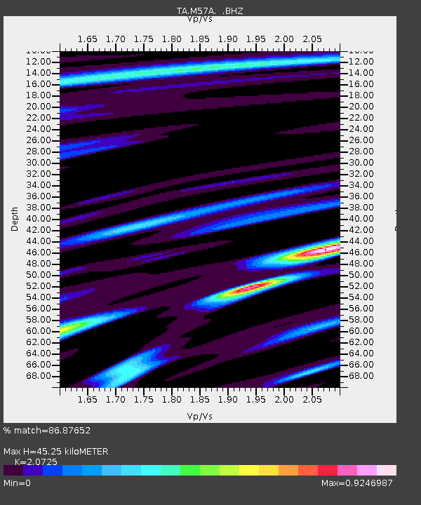
| Estimated Moho Depth: |
45.25 km |
| Estimated Crust Vp/Vs: |
2.07 |
| Assumed Crust Vp: |
6.121 km/s |
| Estimated Crust Vs: |
2.953 km/s |
| Estimated Crust Poisson's Ratio: |
0.35 |
|
| Radial Match: |
86.87652 % |
| Radial Bump: |
400 |
| Transverse Match: |
66.1858 % |
| Transverse Bump: |
400 |
| SOD ConfigId: |
626651 |
| Insert Time: |
2014-04-19 01:48:06.745 +0000 |
| GWidth: |
2.5 |
| Max Bumps: |
400 |
| Tol: |
0.001 |
|
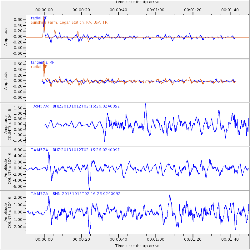
Signal To Noise
| Channel | StoN | STA | LTA |
| TA:M57A: :BHZ:20131012T02:16:26.024009Z | 10.075151 | 2.1369551E-6 | 2.1210153E-7 |
| TA:M57A: :BHN:20131012T02:16:26.024009Z | 5.1580615 | 8.4821875E-7 | 1.6444525E-7 |
| TA:M57A: :BHE:20131012T02:16:26.024009Z | 4.1880116 | 6.4516354E-7 | 1.5405008E-7 |
| Arrivals |
| Ps | 8.4 SECOND |
| PpPs | 21 SECOND |
| PsPs/PpSs | 30 SECOND |


