You are here: Home > Network List > TA - USArray Transportable Network (new EarthScope stations) Stations List
> Station M65A Busby, Falmouth, MA, USA > Earthquake Result Viewer
M65A Busby, Falmouth, MA, USA - Earthquake Result Viewer

| Earthquake location: |
Near Coast Of Venezuela |
| Earthquake latitude/longitude: |
10.9/-62.3 |
| Earthquake time(UTC): |
2013/10/12 (285) 02:10:27 GMT |
| Earthquake Depth: |
63 km |
| Earthquake Magnitude: |
6.0 MWW, 6.0 MWW, 6.0 MWB, 6.0 MWC, 6.0 MI |
| Earthquake Catalog/Contributor: |
NEIC PDE/NEIC COMCAT |
|
| Network: |
TA USArray Transportable Network (new EarthScope stations) |
| Station: |
M65A Busby, Falmouth, MA, USA |
| Lat/Lon: |
41.56 N/70.65 W |
| Elevation: |
22 m |
|
| Distance: |
31.4 deg |
| Az: |
347.954 deg |
| Baz: |
164.149 deg |
| Ray Param: |
0.07894731 |
| Estimated Moho Depth: |
32.0 km |
| Estimated Crust Vp/Vs: |
2.04 |
| Assumed Crust Vp: |
6.472 km/s |
| Estimated Crust Vs: |
3.176 km/s |
| Estimated Crust Poisson's Ratio: |
0.34 |
|
| Radial Match: |
81.69024 % |
| Radial Bump: |
400 |
| Transverse Match: |
45.115833 % |
| Transverse Bump: |
400 |
| SOD ConfigId: |
626651 |
| Insert Time: |
2014-04-19 01:48:28.249 +0000 |
| GWidth: |
2.5 |
| Max Bumps: |
400 |
| Tol: |
0.001 |
|
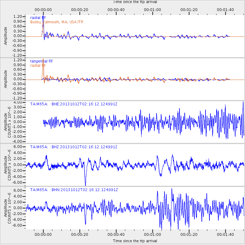
Signal To Noise
| Channel | StoN | STA | LTA |
| TA:M65A: :BHZ:20131012T02:16:12.124991Z | 3.1800537 | 1.3399282E-6 | 4.2135395E-7 |
| TA:M65A: :BHN:20131012T02:16:12.124991Z | 1.754923 | 9.696557E-7 | 5.5253463E-7 |
| TA:M65A: :BHE:20131012T02:16:12.124991Z | 1.6976265 | 8.586323E-7 | 5.05784E-7 |
| Arrivals |
| Ps | 5.5 SECOND |
| PpPs | 14 SECOND |
| PsPs/PpSs | 20 SECOND |


