You are here: Home > Network List > TA - USArray Transportable Network (new EarthScope stations) Stations List
> Station N53A Lisbon, OH, USA > Earthquake Result Viewer
N53A Lisbon, OH, USA - Earthquake Result Viewer
| Earthquake location: |
Near Coast Of Venezuela |
| Earthquake latitude/longitude: |
10.9/-62.3 |
| Earthquake time(UTC): |
2013/10/12 (285) 02:10:27 GMT |
| Earthquake Depth: |
63 km |
| Earthquake Magnitude: |
6.0 MWW, 6.0 MWW, 6.0 MWB, 6.0 MWC, 6.0 MI |
| Earthquake Catalog/Contributor: |
NEIC PDE/NEIC COMCAT |
|
| Network: |
TA USArray Transportable Network (new EarthScope stations) |
| Station: |
N53A Lisbon, OH, USA |
| Lat/Lon: |
40.81 N/80.84 W |
| Elevation: |
360 m |
|
| Distance: |
34.0 deg |
| Az: |
334.435 deg |
| Baz: |
146.058 deg |
| Ray Param: |
0.07780811 |
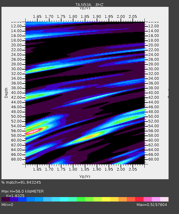
| Estimated Moho Depth: |
56.0 km |
| Estimated Crust Vp/Vs: |
1.63 |
| Assumed Crust Vp: |
6.483 km/s |
| Estimated Crust Vs: |
3.971 km/s |
| Estimated Crust Poisson's Ratio: |
0.20 |
|
| Radial Match: |
91.943245 % |
| Radial Bump: |
250 |
| Transverse Match: |
76.23618 % |
| Transverse Bump: |
372 |
| SOD ConfigId: |
626651 |
| Insert Time: |
2014-04-19 01:49:06.628 +0000 |
| GWidth: |
2.5 |
| Max Bumps: |
400 |
| Tol: |
0.001 |
|

Signal To Noise
| Channel | StoN | STA | LTA |
| TA:N53A: :BHZ:20131012T02:16:34.499991Z | 9.70917 | 2.3107857E-6 | 2.3800034E-7 |
| TA:N53A: :BHN:20131012T02:16:34.499991Z | 5.8062367 | 1.2186262E-6 | 2.0988226E-7 |
| TA:N53A: :BHE:20131012T02:16:34.499991Z | 4.296878 | 7.3770565E-7 | 1.716841E-7 |
| Arrivals |
| Ps | 6.0 SECOND |
| PpPs | 21 SECOND |
| PsPs/PpSs | 27 SECOND |


