You are here: Home > Network List > TA - USArray Transportable Network (new EarthScope stations) Stations List
> Station N56A West Decatur, PA, USA > Earthquake Result Viewer
N56A West Decatur, PA, USA - Earthquake Result Viewer
| Earthquake location: |
Near Coast Of Venezuela |
| Earthquake latitude/longitude: |
10.9/-62.3 |
| Earthquake time(UTC): |
2013/10/12 (285) 02:10:27 GMT |
| Earthquake Depth: |
63 km |
| Earthquake Magnitude: |
6.0 MWW, 6.0 MWW, 6.0 MWB, 6.0 MWC, 6.0 MI |
| Earthquake Catalog/Contributor: |
NEIC PDE/NEIC COMCAT |
|
| Network: |
TA USArray Transportable Network (new EarthScope stations) |
| Station: |
N56A West Decatur, PA, USA |
| Lat/Lon: |
40.92 N/78.30 W |
| Elevation: |
561 m |
|
| Distance: |
33.1 deg |
| Az: |
337.508 deg |
| Baz: |
150.277 deg |
| Ray Param: |
0.07823205 |
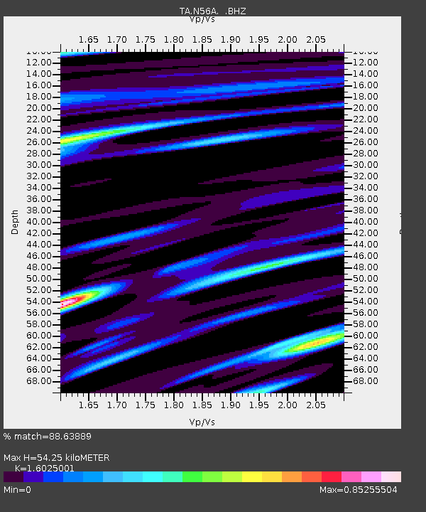
| Estimated Moho Depth: |
54.25 km |
| Estimated Crust Vp/Vs: |
1.60 |
| Assumed Crust Vp: |
6.121 km/s |
| Estimated Crust Vs: |
3.819 km/s |
| Estimated Crust Poisson's Ratio: |
0.18 |
|
| Radial Match: |
88.63889 % |
| Radial Bump: |
400 |
| Transverse Match: |
61.33252 % |
| Transverse Bump: |
400 |
| SOD ConfigId: |
626651 |
| Insert Time: |
2014-04-19 01:49:16.873 +0000 |
| GWidth: |
2.5 |
| Max Bumps: |
400 |
| Tol: |
0.001 |
|

Signal To Noise
| Channel | StoN | STA | LTA |
| TA:N56A: :BHZ:20131012T02:16:26.499991Z | 8.730879 | 1.8429623E-6 | 2.1108555E-7 |
| TA:N56A: :BHN:20131012T02:16:26.499991Z | 5.5530176 | 7.8794335E-7 | 1.4189462E-7 |
| TA:N56A: :BHE:20131012T02:16:26.499991Z | 3.739985 | 6.328689E-7 | 1.6921696E-7 |
| Arrivals |
| Ps | 5.8 SECOND |
| PpPs | 21 SECOND |
| PsPs/PpSs | 27 SECOND |


