You are here: Home > Network List > TA - USArray Transportable Network (new EarthScope stations) Stations List
> Station O03E Paynes Creek, CA, USA > Earthquake Result Viewer
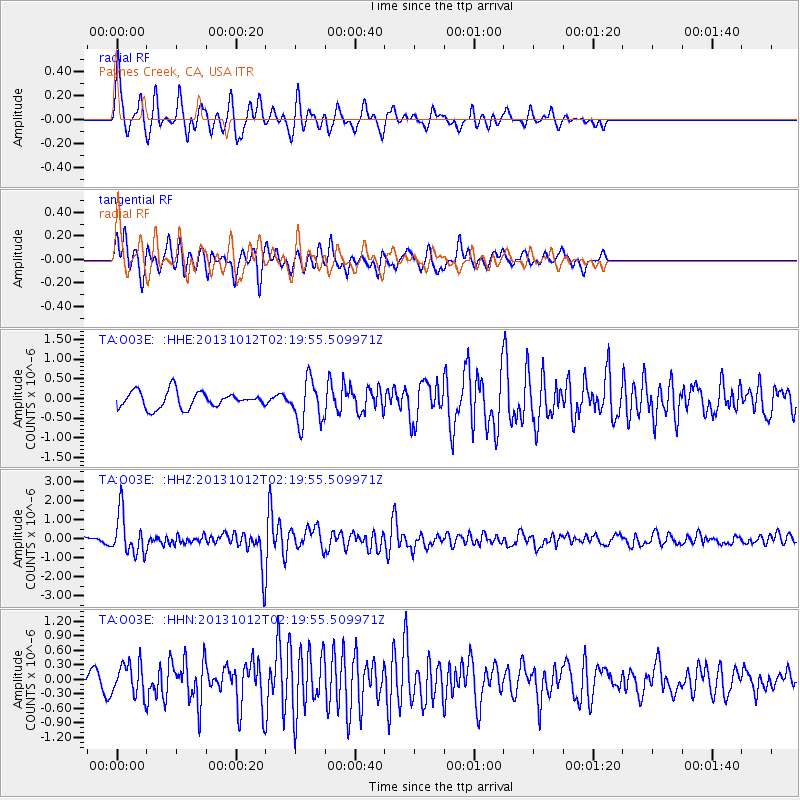
O03E Paynes Creek, CA, USA - Earthquake Result Viewer
*The percent match for this event was below the threshold and hence no stack was calculated.
| Earthquake location: |
Near Coast Of Venezuela |
| Earthquake latitude/longitude: |
10.9/-62.3 |
| Earthquake time(UTC): |
2013/10/12 (285) 02:10:27 GMT |
| Earthquake Depth: |
63 km |
| Earthquake Magnitude: |
6.0 MWW, 6.0 MWW, 6.0 MWB, 6.0 MWC, 6.0 MI |
| Earthquake Catalog/Contributor: |
NEIC PDE/NEIC COMCAT |
|
| Network: |
TA USArray Transportable Network (new EarthScope stations) |
| Station: |
O03E Paynes Creek, CA, USA |
| Lat/Lon: |
40.29 N/121.80 W |
| Elevation: |
967 m |
|
| Distance: |
59.8 deg |
| Az: |
310.345 deg |
| Baz: |
101.846 deg |
| Ray Param: |
$rayparam |
*The percent match for this event was below the threshold and hence was not used in the summary stack. |
|
| Radial Match: |
77.70566 % |
| Radial Bump: |
400 |
| Transverse Match: |
76.33409 % |
| Transverse Bump: |
340 |
| SOD ConfigId: |
626651 |
| Insert Time: |
2014-04-19 01:49:40.122 +0000 |
| GWidth: |
2.5 |
| Max Bumps: |
400 |
| Tol: |
0.001 |
|
Signal To Noise
| Channel | StoN | STA | LTA |
| TA:O03E: :HHZ:20131012T02:19:55.509971Z | 8.206859 | 1.0644302E-6 | 1.2970007E-7 |
| TA:O03E: :HHN:20131012T02:19:55.509971Z | 1.9002333 | 3.2936225E-7 | 1.7332727E-7 |
| TA:O03E: :HHE:20131012T02:19:55.509971Z | 2.6312046 | 5.463081E-7 | 2.076266E-7 |
| Arrivals |
| Ps | |
| PpPs | |
| PsPs/PpSs | |


