You are here: Home > Network List > TA - USArray Transportable Network (new EarthScope stations) Stations List
> Station O58A Lewisberry, PA, USA > Earthquake Result Viewer
O58A Lewisberry, PA, USA - Earthquake Result Viewer
| Earthquake location: |
Near Coast Of Venezuela |
| Earthquake latitude/longitude: |
10.9/-62.3 |
| Earthquake time(UTC): |
2013/10/12 (285) 02:10:27 GMT |
| Earthquake Depth: |
63 km |
| Earthquake Magnitude: |
6.0 MWW, 6.0 MWW, 6.0 MWB, 6.0 MWC, 6.0 MI |
| Earthquake Catalog/Contributor: |
NEIC PDE/NEIC COMCAT |
|
| Network: |
TA USArray Transportable Network (new EarthScope stations) |
| Station: |
O58A Lewisberry, PA, USA |
| Lat/Lon: |
40.12 N/76.92 W |
| Elevation: |
321 m |
|
| Distance: |
31.9 deg |
| Az: |
338.502 deg |
| Baz: |
152.005 deg |
| Ray Param: |
0.078757785 |
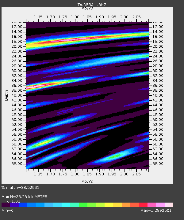
| Estimated Moho Depth: |
36.25 km |
| Estimated Crust Vp/Vs: |
1.63 |
| Assumed Crust Vp: |
6.121 km/s |
| Estimated Crust Vs: |
3.755 km/s |
| Estimated Crust Poisson's Ratio: |
0.20 |
|
| Radial Match: |
88.52932 % |
| Radial Bump: |
333 |
| Transverse Match: |
67.84408 % |
| Transverse Bump: |
400 |
| SOD ConfigId: |
626651 |
| Insert Time: |
2014-04-19 01:50:08.009 +0000 |
| GWidth: |
2.5 |
| Max Bumps: |
400 |
| Tol: |
0.001 |
|
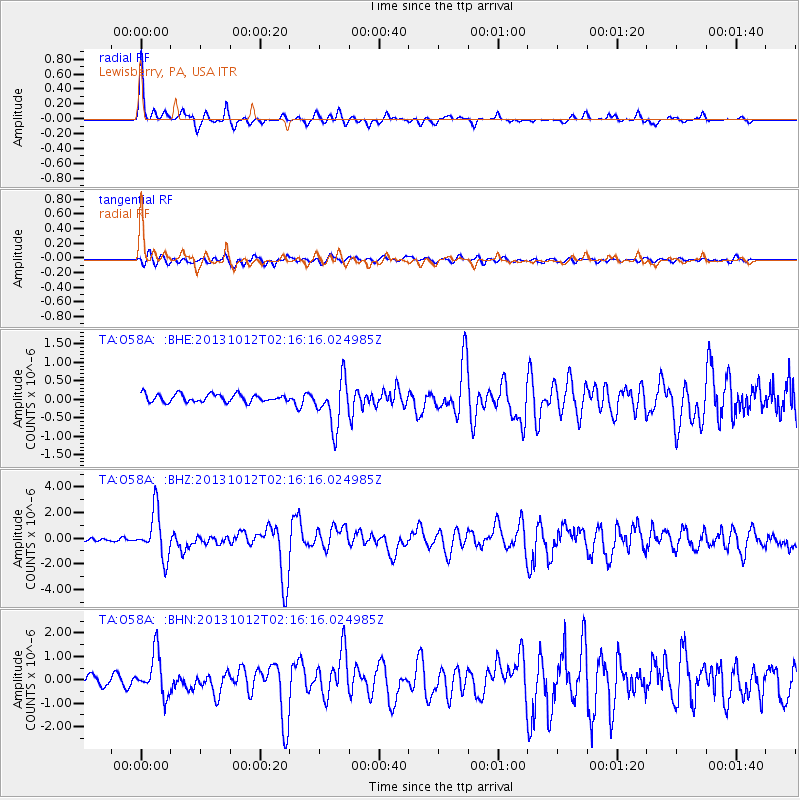
Signal To Noise
| Channel | StoN | STA | LTA |
| TA:O58A: :BHZ:20131012T02:16:16.024985Z | 8.715049 | 1.7973227E-6 | 2.0623207E-7 |
| TA:O58A: :BHN:20131012T02:16:16.024985Z | 5.3008375 | 8.9971996E-7 | 1.6973166E-7 |
| TA:O58A: :BHE:20131012T02:16:16.024985Z | 5.9945483 | 6.341377E-7 | 1.0578573E-7 |
| Arrivals |
| Ps | 4.0 SECOND |
| PpPs | 14 SECOND |
| PsPs/PpSs | 18 SECOND |


