You are here: Home > Network List > TA - USArray Transportable Network (new EarthScope stations) Stations List
> Station P59A Jarrettsville, MD, USA > Earthquake Result Viewer
P59A Jarrettsville, MD, USA - Earthquake Result Viewer
| Earthquake location: |
Near Coast Of Venezuela |
| Earthquake latitude/longitude: |
10.9/-62.3 |
| Earthquake time(UTC): |
2013/10/12 (285) 02:10:27 GMT |
| Earthquake Depth: |
63 km |
| Earthquake Magnitude: |
6.0 MWW, 6.0 MWW, 6.0 MWB, 6.0 MWC, 6.0 MI |
| Earthquake Catalog/Contributor: |
NEIC PDE/NEIC COMCAT |
|
| Network: |
TA USArray Transportable Network (new EarthScope stations) |
| Station: |
P59A Jarrettsville, MD, USA |
| Lat/Lon: |
39.61 N/76.43 W |
| Elevation: |
157 m |
|
| Distance: |
31.2 deg |
| Az: |
338.684 deg |
| Baz: |
152.472 deg |
| Ray Param: |
0.07902455 |
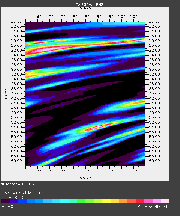
| Estimated Moho Depth: |
17.5 km |
| Estimated Crust Vp/Vs: |
2.10 |
| Assumed Crust Vp: |
6.419 km/s |
| Estimated Crust Vs: |
3.06 km/s |
| Estimated Crust Poisson's Ratio: |
0.35 |
|
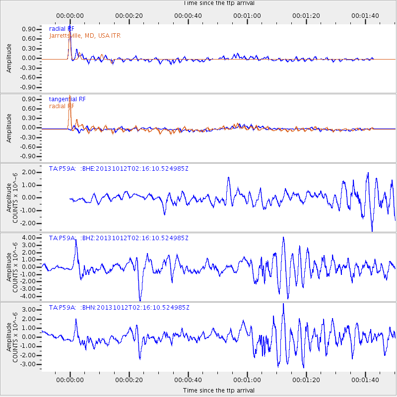
| Radial Match: |
87.18636 % |
| Radial Bump: |
372 |
| Transverse Match: |
45.160786 % |
| Transverse Bump: |
400 |
| SOD ConfigId: |
626651 |
| Insert Time: |
2014-04-19 01:50:58.161 +0000 |
| GWidth: |
2.5 |
| Max Bumps: |
400 |
| Tol: |
0.001 |
|
Signal To Noise
| Channel | StoN | STA | LTA |
| TA:P59A: :BHZ:20131012T02:16:10.524985Z | 5.719506 | 1.4022777E-6 | 2.4517462E-7 |
| TA:P59A: :BHN:20131012T02:16:10.524985Z | 2.2821758 | 7.3708287E-7 | 3.2297376E-7 |
| TA:P59A: :BHE:20131012T02:16:10.524985Z | 2.133596 | 4.9555075E-7 | 2.3226083E-7 |
| Arrivals |
| Ps | 3.2 SECOND |
| PpPs | 7.9 SECOND |
| PsPs/PpSs | 11 SECOND |


