You are here: Home > Network List > TA - USArray Transportable Network (new EarthScope stations) Stations List
> Station Q24A Divide, CO, USA > Earthquake Result Viewer
Q24A Divide, CO, USA - Earthquake Result Viewer

| Earthquake location: |
Near Coast Of Venezuela |
| Earthquake latitude/longitude: |
10.9/-62.3 |
| Earthquake time(UTC): |
2013/10/12 (285) 02:10:27 GMT |
| Earthquake Depth: |
63 km |
| Earthquake Magnitude: |
6.0 MWW, 6.0 MWW, 6.0 MWB, 6.0 MWC, 6.0 MI |
| Earthquake Catalog/Contributor: |
NEIC PDE/NEIC COMCAT |
|
| Network: |
TA USArray Transportable Network (new EarthScope stations) |
| Station: |
Q24A Divide, CO, USA |
| Lat/Lon: |
38.96 N/105.15 W |
| Elevation: |
2775 m |
|
| Distance: |
47.2 deg |
| Az: |
313.765 deg |
| Baz: |
114.517 deg |
| Ray Param: |
0.06994761 |
| Estimated Moho Depth: |
22.0 km |
| Estimated Crust Vp/Vs: |
1.74 |
| Assumed Crust Vp: |
6.159 km/s |
| Estimated Crust Vs: |
3.539 km/s |
| Estimated Crust Poisson's Ratio: |
0.25 |
|
| Radial Match: |
87.11769 % |
| Radial Bump: |
255 |
| Transverse Match: |
51.64113 % |
| Transverse Bump: |
400 |
| SOD ConfigId: |
626651 |
| Insert Time: |
2014-04-19 01:51:06.239 +0000 |
| GWidth: |
2.5 |
| Max Bumps: |
400 |
| Tol: |
0.001 |
|
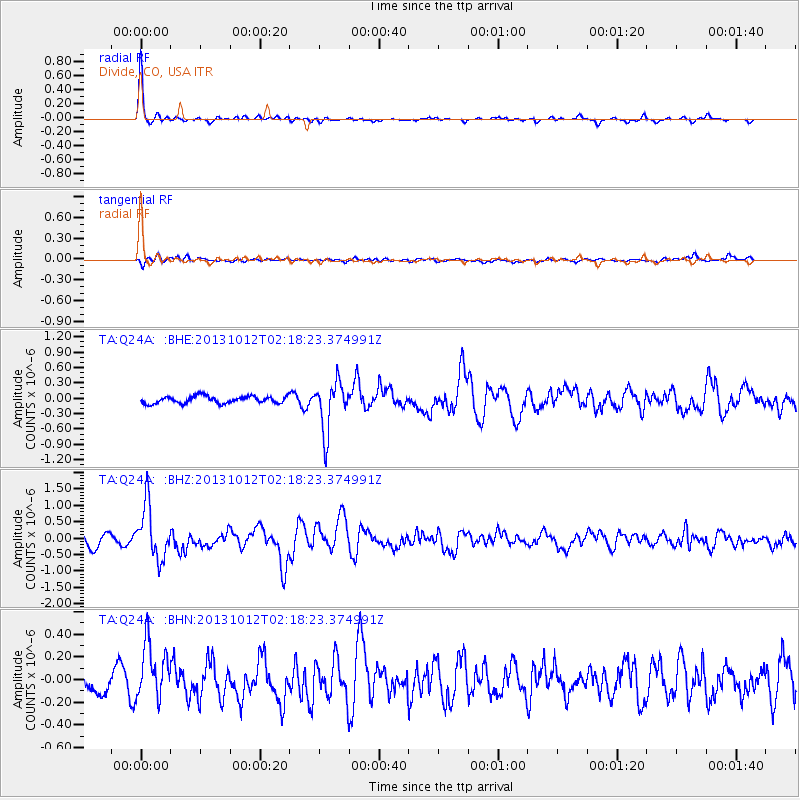
Signal To Noise
| Channel | StoN | STA | LTA |
| TA:Q24A: :BHZ:20131012T02:18:23.374991Z | 4.5035496 | 8.062487E-7 | 1.7902516E-7 |
| TA:Q24A: :BHN:20131012T02:18:23.374991Z | 2.7447588 | 2.527031E-7 | 9.206751E-8 |
| TA:Q24A: :BHE:20131012T02:18:23.374991Z | 6.9682083 | 4.853457E-7 | 6.965144E-8 |
| Arrivals |
| Ps | 2.8 SECOND |
| PpPs | 9.2 SECOND |
| PsPs/PpSs | 12 SECOND |


