You are here: Home > Network List > TA - USArray Transportable Network (new EarthScope stations) Stations List
> Station Q54A Coxs Mills, WV, USA > Earthquake Result Viewer
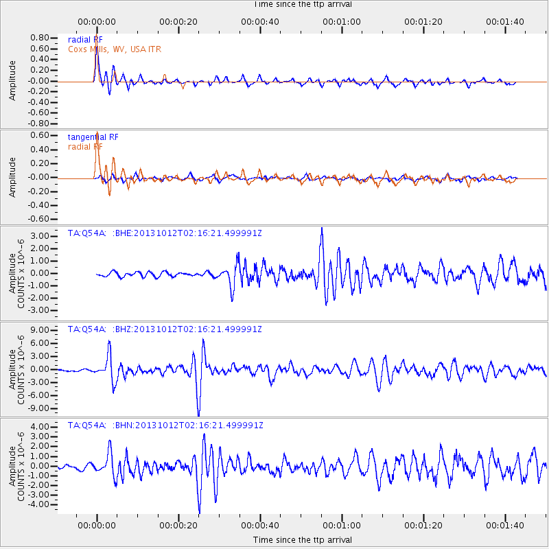
Q54A Coxs Mills, WV, USA - Earthquake Result Viewer
| Earthquake location: |
Near Coast Of Venezuela |
| Earthquake latitude/longitude: |
10.9/-62.3 |
| Earthquake time(UTC): |
2013/10/12 (285) 02:10:27 GMT |
| Earthquake Depth: |
63 km |
| Earthquake Magnitude: |
6.0 MWW, 6.0 MWW, 6.0 MWB, 6.0 MWC, 6.0 MI |
| Earthquake Catalog/Contributor: |
NEIC PDE/NEIC COMCAT |
|
| Network: |
TA USArray Transportable Network (new EarthScope stations) |
| Station: |
Q54A Coxs Mills, WV, USA |
| Lat/Lon: |
38.98 N/80.83 W |
| Elevation: |
254 m |
|
| Distance: |
32.5 deg |
| Az: |
332.546 deg |
| Baz: |
144.48 deg |
| Ray Param: |
0.078492776 |
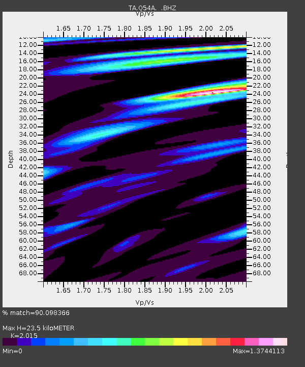
| Estimated Moho Depth: |
23.5 km |
| Estimated Crust Vp/Vs: |
2.02 |
| Assumed Crust Vp: |
6.207 km/s |
| Estimated Crust Vs: |
3.08 km/s |
| Estimated Crust Poisson's Ratio: |
0.34 |
|
| Radial Match: |
90.098366 % |
| Radial Bump: |
346 |
| Transverse Match: |
74.23998 % |
| Transverse Bump: |
400 |
| SOD ConfigId: |
626651 |
| Insert Time: |
2014-04-19 01:51:25.954 +0000 |
| GWidth: |
2.5 |
| Max Bumps: |
400 |
| Tol: |
0.001 |
|
Signal To Noise
| Channel | StoN | STA | LTA |
| TA:Q54A: :BHZ:20131012T02:16:21.499991Z | 12.063354 | 2.9127066E-6 | 2.414508E-7 |
| TA:Q54A: :BHN:20131012T02:16:21.499991Z | 6.8859625 | 1.1846967E-6 | 1.7204518E-7 |
| TA:Q54A: :BHE:20131012T02:16:21.499991Z | 5.292755 | 9.177508E-7 | 1.7339755E-7 |
| Arrivals |
| Ps | 4.1 SECOND |
| PpPs | 11 SECOND |
| PsPs/PpSs | 15 SECOND |


