You are here: Home > Network List > TA - USArray Transportable Network (new EarthScope stations) Stations List
> Station Q56A Snyder Ridge, Maysville, WV, USA > Earthquake Result Viewer
Q56A Snyder Ridge, Maysville, WV, USA - Earthquake Result Viewer

| Earthquake location: |
Near Coast Of Venezuela |
| Earthquake latitude/longitude: |
10.9/-62.3 |
| Earthquake time(UTC): |
2013/10/12 (285) 02:10:27 GMT |
| Earthquake Depth: |
63 km |
| Earthquake Magnitude: |
6.0 MWW, 6.0 MWW, 6.0 MWB, 6.0 MWC, 6.0 MI |
| Earthquake Catalog/Contributor: |
NEIC PDE/NEIC COMCAT |
|
| Network: |
TA USArray Transportable Network (new EarthScope stations) |
| Station: |
Q56A Snyder Ridge, Maysville, WV, USA |
| Lat/Lon: |
39.04 N/79.19 W |
| Elevation: |
430 m |
|
| Distance: |
31.8 deg |
| Az: |
334.603 deg |
| Baz: |
147.254 deg |
| Ray Param: |
0.078777954 |
| Estimated Moho Depth: |
53.5 km |
| Estimated Crust Vp/Vs: |
1.74 |
| Assumed Crust Vp: |
6.159 km/s |
| Estimated Crust Vs: |
3.545 km/s |
| Estimated Crust Poisson's Ratio: |
0.25 |
|
| Radial Match: |
86.51435 % |
| Radial Bump: |
344 |
| Transverse Match: |
69.22739 % |
| Transverse Bump: |
400 |
| SOD ConfigId: |
626651 |
| Insert Time: |
2014-04-19 01:51:31.177 +0000 |
| GWidth: |
2.5 |
| Max Bumps: |
400 |
| Tol: |
0.001 |
|
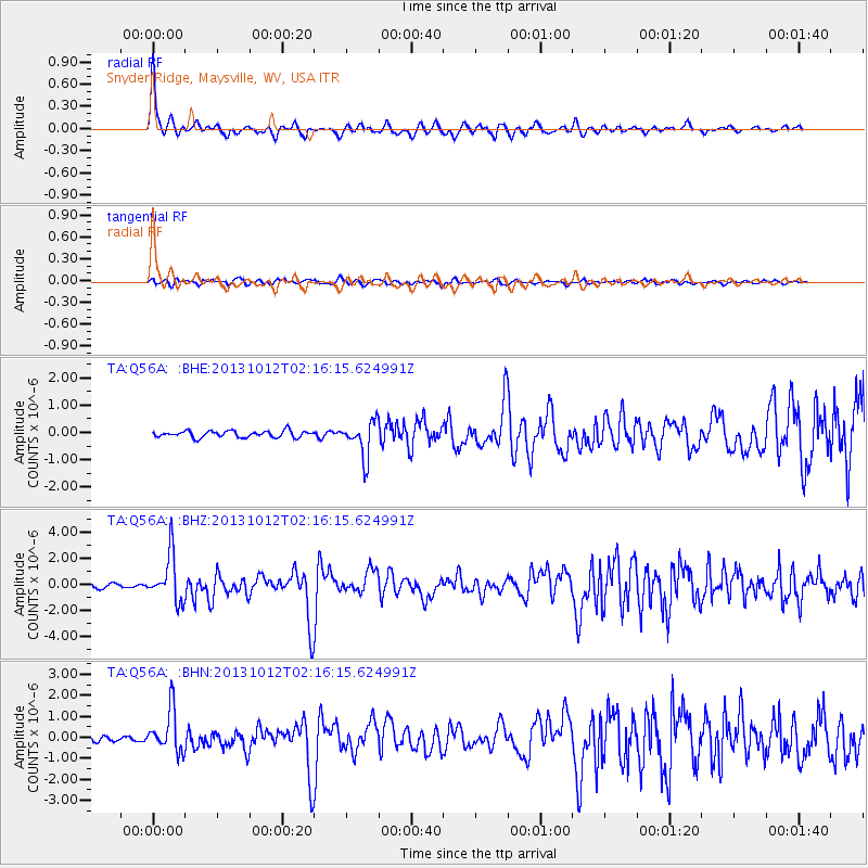
Signal To Noise
| Channel | StoN | STA | LTA |
| TA:Q56A: :BHZ:20131012T02:16:15.624991Z | 10.221194 | 1.7907768E-6 | 1.752023E-7 |
| TA:Q56A: :BHN:20131012T02:16:15.624991Z | 7.165225 | 9.91226E-7 | 1.3833844E-7 |
| TA:Q56A: :BHE:20131012T02:16:15.624991Z | 5.448807 | 6.485464E-7 | 1.190254E-7 |
| Arrivals |
| Ps | 6.9 SECOND |
| PpPs | 22 SECOND |
| PsPs/PpSs | 29 SECOND |


