You are here: Home > Network List > TA - USArray Transportable Network (new EarthScope stations) Stations List
> Station R49A Shelbyville, KY, USA > Earthquake Result Viewer
R49A Shelbyville, KY, USA - Earthquake Result Viewer
| Earthquake location: |
Near Coast Of Venezuela |
| Earthquake latitude/longitude: |
10.9/-62.3 |
| Earthquake time(UTC): |
2013/10/12 (285) 02:10:27 GMT |
| Earthquake Depth: |
63 km |
| Earthquake Magnitude: |
6.0 MWW, 6.0 MWW, 6.0 MWB, 6.0 MWC, 6.0 MI |
| Earthquake Catalog/Contributor: |
NEIC PDE/NEIC COMCAT |
|
| Network: |
TA USArray Transportable Network (new EarthScope stations) |
| Station: |
R49A Shelbyville, KY, USA |
| Lat/Lon: |
38.29 N/85.17 W |
| Elevation: |
251 m |
|
| Distance: |
34.1 deg |
| Az: |
326.953 deg |
| Baz: |
137.105 deg |
| Ray Param: |
0.07775061 |
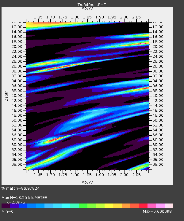
| Estimated Moho Depth: |
18.25 km |
| Estimated Crust Vp/Vs: |
2.10 |
| Assumed Crust Vp: |
6.498 km/s |
| Estimated Crust Vs: |
3.098 km/s |
| Estimated Crust Poisson's Ratio: |
0.35 |
|
| Radial Match: |
86.97824 % |
| Radial Bump: |
400 |
| Transverse Match: |
64.76138 % |
| Transverse Bump: |
400 |
| SOD ConfigId: |
626651 |
| Insert Time: |
2014-04-19 01:51:46.712 +0000 |
| GWidth: |
2.5 |
| Max Bumps: |
400 |
| Tol: |
0.001 |
|
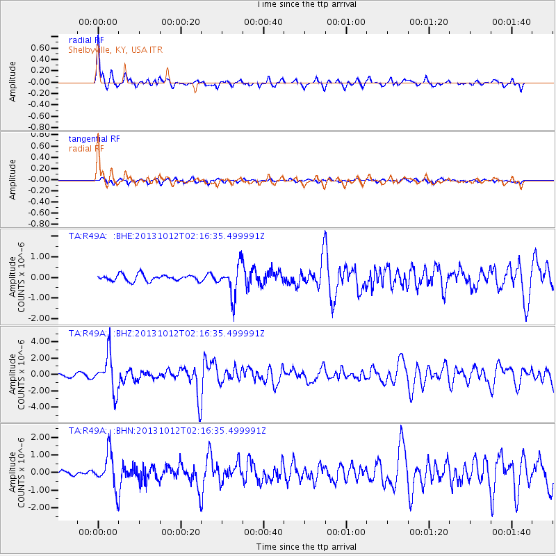
Signal To Noise
| Channel | StoN | STA | LTA |
| TA:R49A: :BHZ:20131012T02:16:35.499991Z | 14.043937 | 2.3601242E-6 | 1.680529E-7 |
| TA:R49A: :BHN:20131012T02:16:35.499991Z | 6.0782633 | 1.0291113E-6 | 1.693101E-7 |
| TA:R49A: :BHE:20131012T02:16:35.499991Z | 5.1204734 | 7.826319E-7 | 1.5284365E-7 |
| Arrivals |
| Ps | 3.3 SECOND |
| PpPs | 8.1 SECOND |
| PsPs/PpSs | 11 SECOND |


