You are here: Home > Network List > TA - USArray Transportable Network (new EarthScope stations) Stations List
> Station R52A Catlettsburg, KY, USA > Earthquake Result Viewer
R52A Catlettsburg, KY, USA - Earthquake Result Viewer

| Earthquake location: |
Near Coast Of Venezuela |
| Earthquake latitude/longitude: |
10.9/-62.3 |
| Earthquake time(UTC): |
2013/10/12 (285) 02:10:27 GMT |
| Earthquake Depth: |
63 km |
| Earthquake Magnitude: |
6.0 MWW, 6.0 MWW, 6.0 MWB, 6.0 MWC, 6.0 MI |
| Earthquake Catalog/Contributor: |
NEIC PDE/NEIC COMCAT |
|
| Network: |
TA USArray Transportable Network (new EarthScope stations) |
| Station: |
R52A Catlettsburg, KY, USA |
| Lat/Lon: |
38.34 N/82.64 W |
| Elevation: |
300 m |
|
| Distance: |
32.8 deg |
| Az: |
329.73 deg |
| Baz: |
140.982 deg |
| Ray Param: |
0.07833787 |
| Estimated Moho Depth: |
43.25 km |
| Estimated Crust Vp/Vs: |
2.08 |
| Assumed Crust Vp: |
6.232 km/s |
| Estimated Crust Vs: |
3.003 km/s |
| Estimated Crust Poisson's Ratio: |
0.35 |
|
| Radial Match: |
89.43815 % |
| Radial Bump: |
400 |
| Transverse Match: |
64.757805 % |
| Transverse Bump: |
400 |
| SOD ConfigId: |
626651 |
| Insert Time: |
2014-04-19 01:51:56.658 +0000 |
| GWidth: |
2.5 |
| Max Bumps: |
400 |
| Tol: |
0.001 |
|
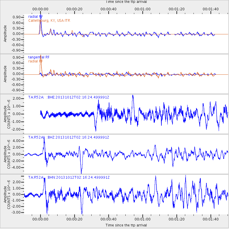
Signal To Noise
| Channel | StoN | STA | LTA |
| TA:R52A: :BHZ:20131012T02:16:24.499991Z | 8.198054 | 1.8937094E-6 | 2.3099497E-7 |
| TA:R52A: :BHN:20131012T02:16:24.499991Z | 5.6575117 | 1.3329304E-6 | 2.3560366E-7 |
| TA:R52A: :BHE:20131012T02:16:24.499991Z | 4.2738 | 8.5870096E-7 | 2.0092212E-7 |
| Arrivals |
| Ps | 7.9 SECOND |
| PpPs | 20 SECOND |
| PsPs/PpSs | 28 SECOND |


