You are here: Home > Network List > TA - USArray Transportable Network (new EarthScope stations) Stations List
> Station S57A Dark Hollow, Roseland, VA, USA > Earthquake Result Viewer
S57A Dark Hollow, Roseland, VA, USA - Earthquake Result Viewer

| Earthquake location: |
Near Coast Of Venezuela |
| Earthquake latitude/longitude: |
10.9/-62.3 |
| Earthquake time(UTC): |
2013/10/12 (285) 02:10:27 GMT |
| Earthquake Depth: |
63 km |
| Earthquake Magnitude: |
6.0 MWW, 6.0 MWW, 6.0 MWB, 6.0 MWC, 6.0 MI |
| Earthquake Catalog/Contributor: |
NEIC PDE/NEIC COMCAT |
|
| Network: |
TA USArray Transportable Network (new EarthScope stations) |
| Station: |
S57A Dark Hollow, Roseland, VA, USA |
| Lat/Lon: |
37.76 N/78.95 W |
| Elevation: |
264 m |
|
| Distance: |
30.6 deg |
| Az: |
333.551 deg |
| Baz: |
146.499 deg |
| Ray Param: |
0.07919154 |
| Estimated Moho Depth: |
55.0 km |
| Estimated Crust Vp/Vs: |
1.60 |
| Assumed Crust Vp: |
6.419 km/s |
| Estimated Crust Vs: |
4.012 km/s |
| Estimated Crust Poisson's Ratio: |
0.18 |
|
| Radial Match: |
90.70356 % |
| Radial Bump: |
339 |
| Transverse Match: |
58.690315 % |
| Transverse Bump: |
400 |
| SOD ConfigId: |
626651 |
| Insert Time: |
2014-04-19 01:52:47.158 +0000 |
| GWidth: |
2.5 |
| Max Bumps: |
400 |
| Tol: |
0.001 |
|
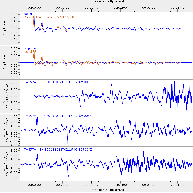
Signal To Noise
| Channel | StoN | STA | LTA |
| TA:S57A: :BHZ:20131012T02:16:05.325004Z | 10.306783 | 1.3830081E-6 | 1.3418426E-7 |
| TA:S57A: :BHN:20131012T02:16:05.325004Z | 7.9710546 | 8.514828E-7 | 1.0682186E-7 |
| TA:S57A: :BHE:20131012T02:16:05.325004Z | 5.9204288 | 5.9234446E-7 | 1.0005094E-7 |
| Arrivals |
| Ps | 5.6 SECOND |
| PpPs | 20 SECOND |
| PsPs/PpSs | 26 SECOND |


