You are here: Home > Network List > TA - USArray Transportable Network (new EarthScope stations) Stations List
> Station S59A Mechanicsville, VA, USA > Earthquake Result Viewer
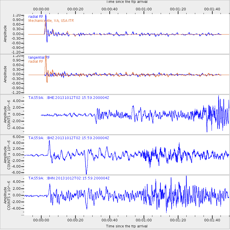
S59A Mechanicsville, VA, USA - Earthquake Result Viewer
*The percent match for this event was below the threshold and hence no stack was calculated.
| Earthquake location: |
Near Coast Of Venezuela |
| Earthquake latitude/longitude: |
10.9/-62.3 |
| Earthquake time(UTC): |
2013/10/12 (285) 02:10:27 GMT |
| Earthquake Depth: |
63 km |
| Earthquake Magnitude: |
6.0 MWW, 6.0 MWW, 6.0 MWB, 6.0 MWC, 6.0 MI |
| Earthquake Catalog/Contributor: |
NEIC PDE/NEIC COMCAT |
|
| Network: |
TA USArray Transportable Network (new EarthScope stations) |
| Station: |
S59A Mechanicsville, VA, USA |
| Lat/Lon: |
37.46 N/77.18 W |
| Elevation: |
40 m |
|
| Distance: |
29.6 deg |
| Az: |
335.614 deg |
| Baz: |
149.363 deg |
| Ray Param: |
$rayparam |
*The percent match for this event was below the threshold and hence was not used in the summary stack. |
|
| Radial Match: |
86.463425 % |
| Radial Bump: |
400 |
| Transverse Match: |
63.402306 % |
| Transverse Bump: |
400 |
| SOD ConfigId: |
626651 |
| Insert Time: |
2014-04-19 01:52:52.566 +0000 |
| GWidth: |
2.5 |
| Max Bumps: |
400 |
| Tol: |
0.001 |
|
Signal To Noise
| Channel | StoN | STA | LTA |
| TA:S59A: :BHZ:20131012T02:15:59.200004Z | 8.091882 | 1.2186904E-6 | 1.5060655E-7 |
| TA:S59A: :BHN:20131012T02:15:59.200004Z | 4.063101 | 5.5766725E-7 | 1.3725165E-7 |
| TA:S59A: :BHE:20131012T02:15:59.200004Z | 2.1948779 | 4.6620144E-7 | 2.1240426E-7 |
| Arrivals |
| Ps | |
| PpPs | |
| PsPs/PpSs | |


