You are here: Home > Network List > TA - USArray Transportable Network (new EarthScope stations) Stations List
> Station T52A Hallie, KY, USA > Earthquake Result Viewer
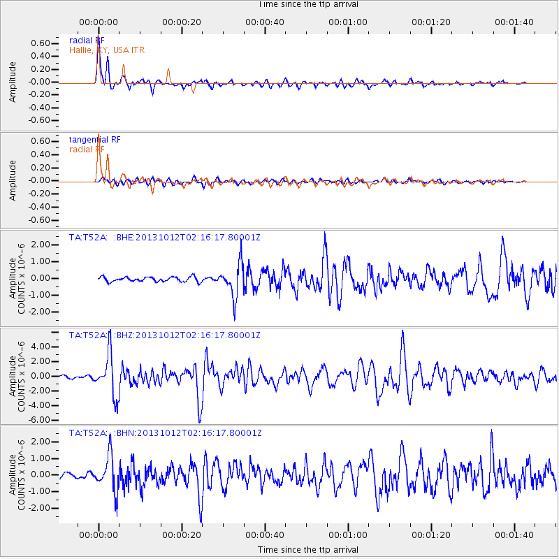
T52A Hallie, KY, USA - Earthquake Result Viewer
| Earthquake location: |
Near Coast Of Venezuela |
| Earthquake latitude/longitude: |
10.9/-62.3 |
| Earthquake time(UTC): |
2013/10/12 (285) 02:10:27 GMT |
| Earthquake Depth: |
63 km |
| Earthquake Magnitude: |
6.0 MWW, 6.0 MWW, 6.0 MWB, 6.0 MWC, 6.0 MI |
| Earthquake Catalog/Contributor: |
NEIC PDE/NEIC COMCAT |
|
| Network: |
TA USArray Transportable Network (new EarthScope stations) |
| Station: |
T52A Hallie, KY, USA |
| Lat/Lon: |
37.11 N/82.99 W |
| Elevation: |
436 m |
|
| Distance: |
32.1 deg |
| Az: |
327.876 deg |
| Baz: |
139.209 deg |
| Ray Param: |
0.07867236 |
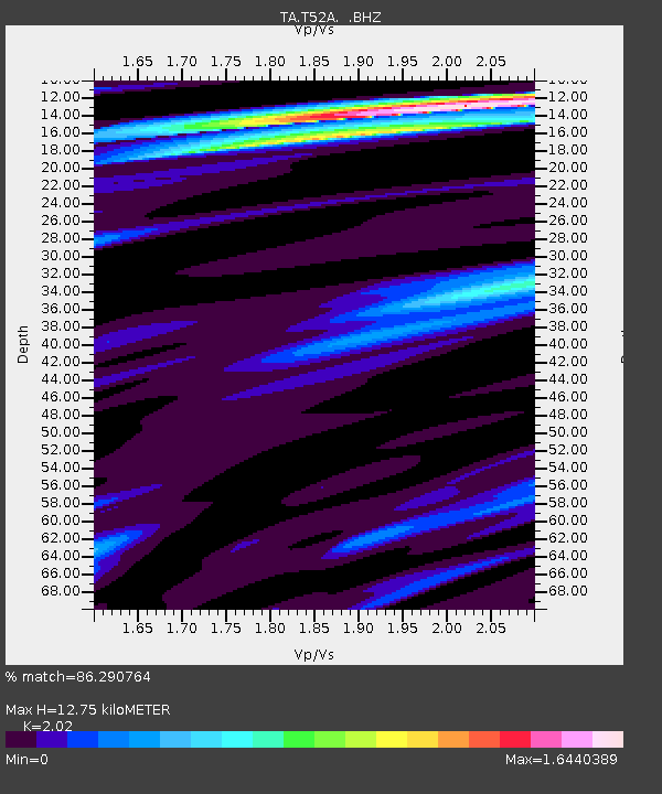
| Estimated Moho Depth: |
12.75 km |
| Estimated Crust Vp/Vs: |
2.02 |
| Assumed Crust Vp: |
6.476 km/s |
| Estimated Crust Vs: |
3.206 km/s |
| Estimated Crust Poisson's Ratio: |
0.34 |
|
| Radial Match: |
86.290764 % |
| Radial Bump: |
400 |
| Transverse Match: |
69.69992 % |
| Transverse Bump: |
400 |
| SOD ConfigId: |
626651 |
| Insert Time: |
2014-04-19 01:53:20.213 +0000 |
| GWidth: |
2.5 |
| Max Bumps: |
400 |
| Tol: |
0.001 |
|
Signal To Noise
| Channel | StoN | STA | LTA |
| TA:T52A: :BHZ:20131012T02:16:17.80001Z | 14.32825 | 2.91577E-6 | 2.0349798E-7 |
| TA:T52A: :BHN:20131012T02:16:17.80001Z | 8.134379 | 1.1357255E-6 | 1.3962041E-7 |
| TA:T52A: :BHE:20131012T02:16:17.80001Z | 7.1670585 | 9.846237E-7 | 1.3738185E-7 |
| Arrivals |
| Ps | 2.2 SECOND |
| PpPs | 5.5 SECOND |
| PsPs/PpSs | 7.7 SECOND |


