You are here: Home > Network List > TA - USArray Transportable Network (new EarthScope stations) Stations List
> Station T53A Wise, VA, USA > Earthquake Result Viewer
T53A Wise, VA, USA - Earthquake Result Viewer
| Earthquake location: |
Near Coast Of Venezuela |
| Earthquake latitude/longitude: |
10.9/-62.3 |
| Earthquake time(UTC): |
2013/10/12 (285) 02:10:27 GMT |
| Earthquake Depth: |
63 km |
| Earthquake Magnitude: |
6.0 MWW, 6.0 MWW, 6.0 MWB, 6.0 MWC, 6.0 MI |
| Earthquake Catalog/Contributor: |
NEIC PDE/NEIC COMCAT |
|
| Network: |
TA USArray Transportable Network (new EarthScope stations) |
| Station: |
T53A Wise, VA, USA |
| Lat/Lon: |
36.98 N/82.54 W |
| Elevation: |
818 m |
|
| Distance: |
31.7 deg |
| Az: |
328.241 deg |
| Baz: |
139.789 deg |
| Ray Param: |
0.078811884 |
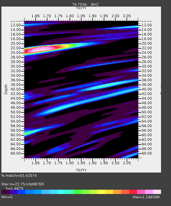
| Estimated Moho Depth: |
22.75 km |
| Estimated Crust Vp/Vs: |
1.67 |
| Assumed Crust Vp: |
6.476 km/s |
| Estimated Crust Vs: |
3.884 km/s |
| Estimated Crust Poisson's Ratio: |
0.22 |
|
| Radial Match: |
83.42574 % |
| Radial Bump: |
400 |
| Transverse Match: |
72.66427 % |
| Transverse Bump: |
400 |
| SOD ConfigId: |
626651 |
| Insert Time: |
2014-04-19 01:53:21.142 +0000 |
| GWidth: |
2.5 |
| Max Bumps: |
400 |
| Tol: |
0.001 |
|

Signal To Noise
| Channel | StoN | STA | LTA |
| TA:T53A: :BHZ:20131012T02:16:14.92501Z | 25.210705 | 2.874645E-6 | 1.1402477E-7 |
| TA:T53A: :BHN:20131012T02:16:14.92501Z | 10.998295 | 1.2503458E-6 | 1.1368542E-7 |
| TA:T53A: :BHE:20131012T02:16:14.92501Z | 6.9812574 | 9.24421E-7 | 1.3241468E-7 |
| Arrivals |
| Ps | 2.6 SECOND |
| PpPs | 8.6 SECOND |
| PsPs/PpSs | 11 SECOND |


