You are here: Home > Network List > TA - USArray Transportable Network (new EarthScope stations) Stations List
> Station V49A McMinnville, TN, USA > Earthquake Result Viewer
V49A McMinnville, TN, USA - Earthquake Result Viewer

| Earthquake location: |
Near Coast Of Venezuela |
| Earthquake latitude/longitude: |
10.9/-62.3 |
| Earthquake time(UTC): |
2013/10/12 (285) 02:10:27 GMT |
| Earthquake Depth: |
63 km |
| Earthquake Magnitude: |
6.0 MWW, 6.0 MWW, 6.0 MWB, 6.0 MWC, 6.0 MI |
| Earthquake Catalog/Contributor: |
NEIC PDE/NEIC COMCAT |
|
| Network: |
TA USArray Transportable Network (new EarthScope stations) |
| Station: |
V49A McMinnville, TN, USA |
| Lat/Lon: |
35.77 N/85.90 W |
| Elevation: |
329 m |
|
| Distance: |
32.7 deg |
| Az: |
322.973 deg |
| Baz: |
133.342 deg |
| Ray Param: |
0.07838827 |
| Estimated Moho Depth: |
44.25 km |
| Estimated Crust Vp/Vs: |
2.10 |
| Assumed Crust Vp: |
6.35 km/s |
| Estimated Crust Vs: |
3.031 km/s |
| Estimated Crust Poisson's Ratio: |
0.35 |
|
| Radial Match: |
93.27133 % |
| Radial Bump: |
280 |
| Transverse Match: |
72.99008 % |
| Transverse Bump: |
400 |
| SOD ConfigId: |
626651 |
| Insert Time: |
2014-04-19 01:54:06.055 +0000 |
| GWidth: |
2.5 |
| Max Bumps: |
400 |
| Tol: |
0.001 |
|
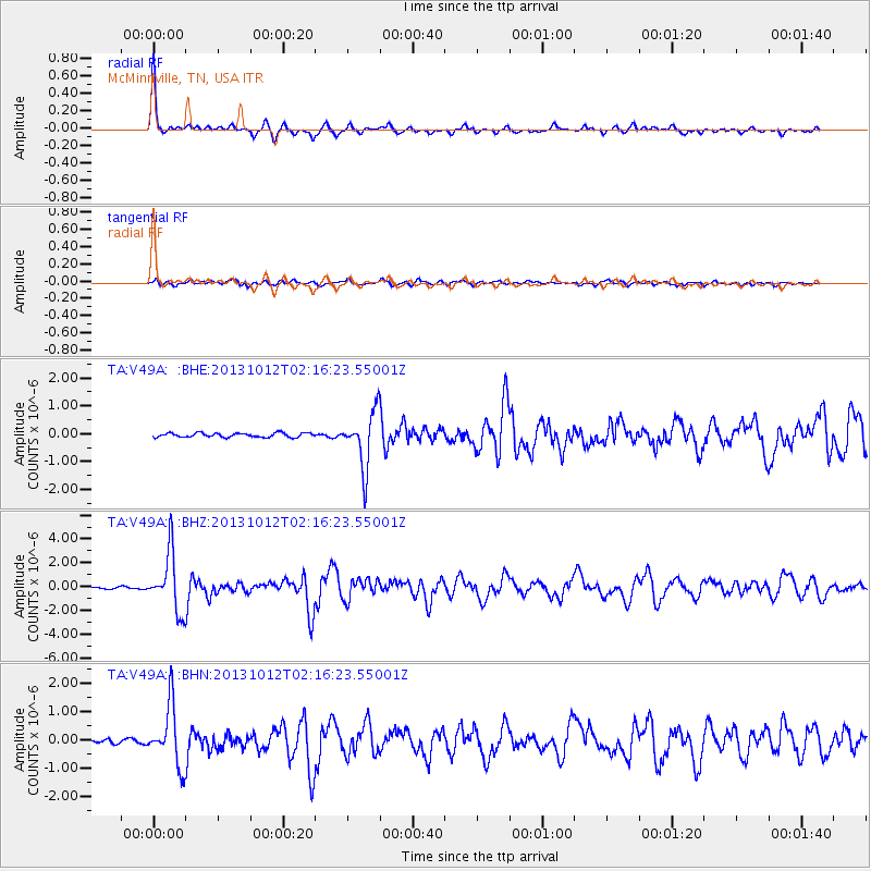
Signal To Noise
| Channel | StoN | STA | LTA |
| TA:V49A: :BHZ:20131012T02:16:23.55001Z | 31.492237 | 2.4303495E-6 | 7.717297E-8 |
| TA:V49A: :BHN:20131012T02:16:23.55001Z | 15.244357 | 1.0589989E-6 | 6.946826E-8 |
| TA:V49A: :BHE:20131012T02:16:23.55001Z | 13.441766 | 1.0042024E-6 | 7.470763E-8 |
| Arrivals |
| Ps | 8.1 SECOND |
| PpPs | 20 SECOND |
| PsPs/PpSs | 28 SECOND |


