You are here: Home > Network List > TA - USArray Transportable Network (new EarthScope stations) Stations List
> Station X43A Marvell, AR, USA > Earthquake Result Viewer
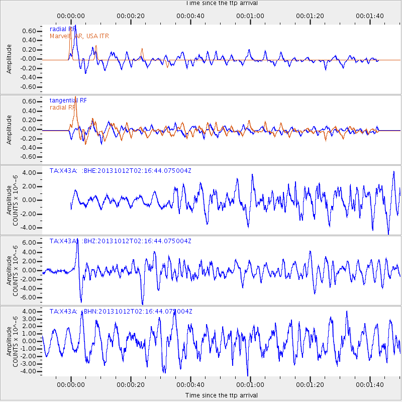
X43A Marvell, AR, USA - Earthquake Result Viewer
*The percent match for this event was below the threshold and hence no stack was calculated.
| Earthquake location: |
Near Coast Of Venezuela |
| Earthquake latitude/longitude: |
10.9/-62.3 |
| Earthquake time(UTC): |
2013/10/12 (285) 02:10:27 GMT |
| Earthquake Depth: |
63 km |
| Earthquake Magnitude: |
6.0 MWW, 6.0 MWW, 6.0 MWB, 6.0 MWC, 6.0 MI |
| Earthquake Catalog/Contributor: |
NEIC PDE/NEIC COMCAT |
|
| Network: |
TA USArray Transportable Network (new EarthScope stations) |
| Station: |
X43A Marvell, AR, USA |
| Lat/Lon: |
34.52 N/90.88 W |
| Elevation: |
53 m |
|
| Distance: |
35.1 deg |
| Az: |
316.613 deg |
| Baz: |
125.207 deg |
| Ray Param: |
$rayparam |
*The percent match for this event was below the threshold and hence was not used in the summary stack. |
|
| Radial Match: |
78.538086 % |
| Radial Bump: |
383 |
| Transverse Match: |
65.29825 % |
| Transverse Bump: |
390 |
| SOD ConfigId: |
626651 |
| Insert Time: |
2014-04-19 01:54:54.215 +0000 |
| GWidth: |
2.5 |
| Max Bumps: |
400 |
| Tol: |
0.001 |
|
Signal To Noise
| Channel | StoN | STA | LTA |
| TA:X43A: :BHZ:20131012T02:16:44.075004Z | 11.434101 | 3.2505875E-6 | 2.8428886E-7 |
| TA:X43A: :BHN:20131012T02:16:44.075004Z | 1.9505512 | 1.7441376E-6 | 8.941768E-7 |
| TA:X43A: :BHE:20131012T02:16:44.075004Z | 1.4911911 | 8.3773915E-7 | 5.617919E-7 |
| Arrivals |
| Ps | |
| PpPs | |
| PsPs/PpSs | |


