You are here: Home > Network List > TA - USArray Transportable Network (new EarthScope stations) Stations List
> Station X51A Calhoun, GA, USA > Earthquake Result Viewer
X51A Calhoun, GA, USA - Earthquake Result Viewer

| Earthquake location: |
Near Coast Of Venezuela |
| Earthquake latitude/longitude: |
10.9/-62.3 |
| Earthquake time(UTC): |
2013/10/12 (285) 02:10:27 GMT |
| Earthquake Depth: |
63 km |
| Earthquake Magnitude: |
6.0 MWW, 6.0 MWW, 6.0 MWB, 6.0 MWC, 6.0 MI |
| Earthquake Catalog/Contributor: |
NEIC PDE/NEIC COMCAT |
|
| Network: |
TA USArray Transportable Network (new EarthScope stations) |
| Station: |
X51A Calhoun, GA, USA |
| Lat/Lon: |
34.57 N/84.86 W |
| Elevation: |
214 m |
|
| Distance: |
31.3 deg |
| Az: |
322.442 deg |
| Baz: |
133.491 deg |
| Ray Param: |
0.07900557 |
| Estimated Moho Depth: |
49.5 km |
| Estimated Crust Vp/Vs: |
1.84 |
| Assumed Crust Vp: |
6.35 km/s |
| Estimated Crust Vs: |
3.451 km/s |
| Estimated Crust Poisson's Ratio: |
0.29 |
|
| Radial Match: |
87.43249 % |
| Radial Bump: |
390 |
| Transverse Match: |
62.534332 % |
| Transverse Bump: |
400 |
| SOD ConfigId: |
626651 |
| Insert Time: |
2014-04-19 01:55:00.197 +0000 |
| GWidth: |
2.5 |
| Max Bumps: |
400 |
| Tol: |
0.001 |
|
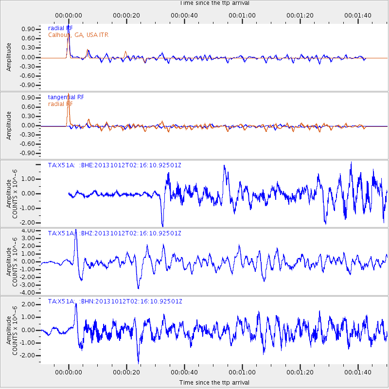
Signal To Noise
| Channel | StoN | STA | LTA |
| TA:X51A: :BHZ:20131012T02:16:10.92501Z | 11.946027 | 1.7313988E-6 | 1.4493511E-7 |
| TA:X51A: :BHN:20131012T02:16:10.92501Z | 6.5033417 | 9.302698E-7 | 1.4304489E-7 |
| TA:X51A: :BHE:20131012T02:16:10.92501Z | 9.794585 | 9.10497E-7 | 9.295922E-8 |
| Arrivals |
| Ps | 7.1 SECOND |
| PpPs | 21 SECOND |
| PsPs/PpSs | 28 SECOND |


