You are here: Home > Network List > TA - USArray Transportable Network (new EarthScope stations) Stations List
> Station X53A Estanollee, GA, USA > Earthquake Result Viewer
X53A Estanollee, GA, USA - Earthquake Result Viewer
| Earthquake location: |
Near Coast Of Venezuela |
| Earthquake latitude/longitude: |
10.9/-62.3 |
| Earthquake time(UTC): |
2013/10/12 (285) 02:10:27 GMT |
| Earthquake Depth: |
63 km |
| Earthquake Magnitude: |
6.0 MWW, 6.0 MWW, 6.0 MWB, 6.0 MWC, 6.0 MI |
| Earthquake Catalog/Contributor: |
NEIC PDE/NEIC COMCAT |
|
| Network: |
TA USArray Transportable Network (new EarthScope stations) |
| Station: |
X53A Estanollee, GA, USA |
| Lat/Lon: |
34.50 N/83.30 W |
| Elevation: |
240 m |
|
| Distance: |
30.3 deg |
| Az: |
324.119 deg |
| Baz: |
135.81 deg |
| Ray Param: |
0.07927641 |
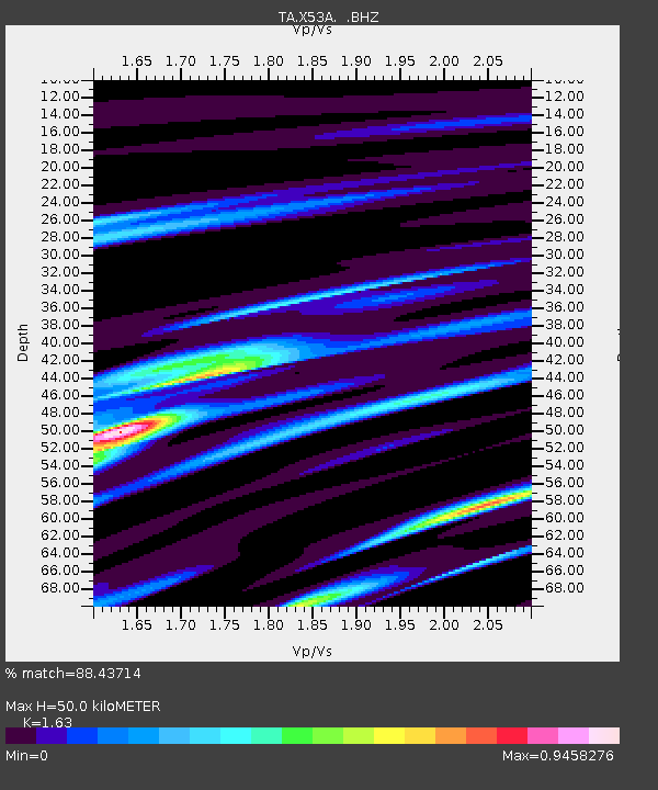
| Estimated Moho Depth: |
50.0 km |
| Estimated Crust Vp/Vs: |
1.63 |
| Assumed Crust Vp: |
6.35 km/s |
| Estimated Crust Vs: |
3.896 km/s |
| Estimated Crust Poisson's Ratio: |
0.20 |
|
| Radial Match: |
88.43714 % |
| Radial Bump: |
344 |
| Transverse Match: |
61.92205 % |
| Transverse Bump: |
400 |
| SOD ConfigId: |
626651 |
| Insert Time: |
2014-04-19 01:55:05.731 +0000 |
| GWidth: |
2.5 |
| Max Bumps: |
400 |
| Tol: |
0.001 |
|

Signal To Noise
| Channel | StoN | STA | LTA |
| TA:X53A: :BHZ:20131012T02:16:02.474998Z | 14.509209 | 2.0525679E-6 | 1.4146657E-7 |
| TA:X53A: :BHN:20131012T02:16:02.474998Z | 8.72328 | 1.0752357E-6 | 1.2326049E-7 |
| TA:X53A: :BHE:20131012T02:16:02.474998Z | 10.420743 | 1.0177787E-6 | 9.766853E-8 |
| Arrivals |
| Ps | 5.4 SECOND |
| PpPs | 19 SECOND |
| PsPs/PpSs | 24 SECOND |


