You are here: Home > Network List > US - United States National Seismic Network Stations List
> Station AMTX Amarillo, Texas, USA > Earthquake Result Viewer
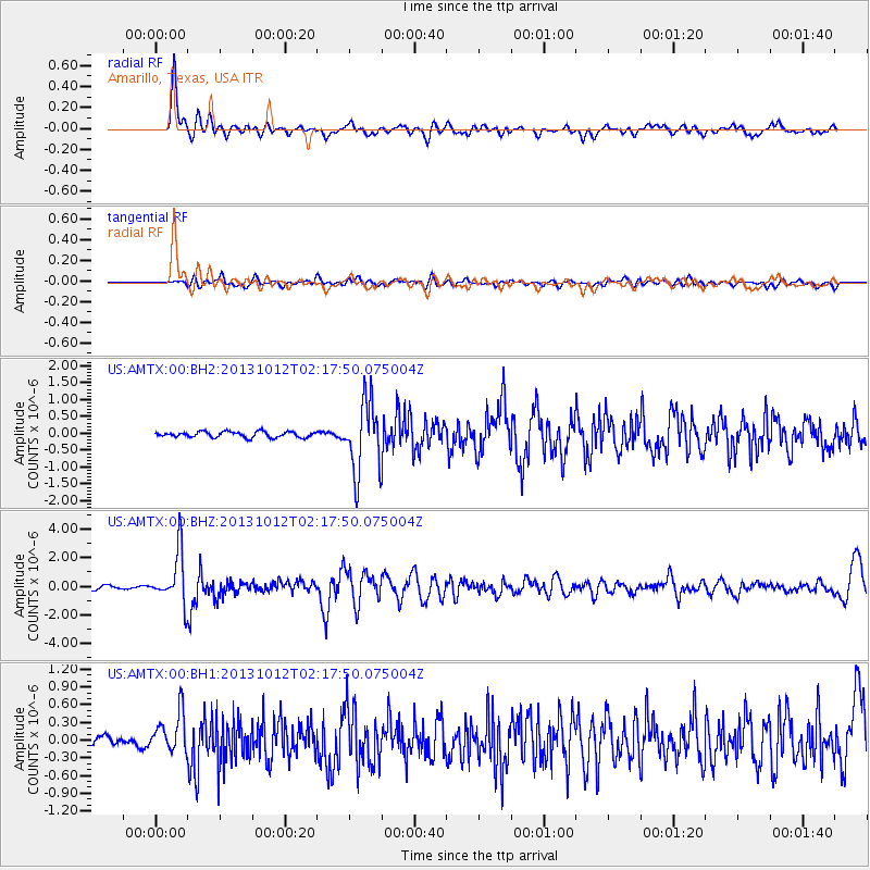
AMTX Amarillo, Texas, USA - Earthquake Result Viewer
*The percent match for this event was below the threshold and hence no stack was calculated.
| Earthquake location: |
Near Coast Of Venezuela |
| Earthquake latitude/longitude: |
10.9/-62.3 |
| Earthquake time(UTC): |
2013/10/12 (285) 02:10:27 GMT |
| Earthquake Depth: |
63 km |
| Earthquake Magnitude: |
6.0 MWW, 6.0 MWW, 6.0 MWB, 6.0 MWC, 6.0 MI |
| Earthquake Catalog/Contributor: |
NEIC PDE/NEIC COMCAT |
|
| Network: |
US United States National Seismic Network |
| Station: |
AMTX Amarillo, Texas, USA |
| Lat/Lon: |
34.53 N/101.41 W |
| Elevation: |
1010 m |
|
| Distance: |
42.7 deg |
| Az: |
309.8 deg |
| Baz: |
113.938 deg |
| Ray Param: |
$rayparam |
*The percent match for this event was below the threshold and hence was not used in the summary stack. |
|
| Radial Match: |
86.466064 % |
| Radial Bump: |
400 |
| Transverse Match: |
62.0672 % |
| Transverse Bump: |
400 |
| SOD ConfigId: |
626651 |
| Insert Time: |
2014-04-19 01:55:48.497 +0000 |
| GWidth: |
2.5 |
| Max Bumps: |
400 |
| Tol: |
0.001 |
|
Signal To Noise
| Channel | StoN | STA | LTA |
| US:AMTX:00:BHZ:20131012T02:17:50.075004Z | 15.382426 | 1.7791285E-6 | 1.15659816E-7 |
| US:AMTX:00:BH1:20131012T02:17:50.075004Z | 3.0611658 | 3.257243E-7 | 1.0640532E-7 |
| US:AMTX:00:BH2:20131012T02:17:50.075004Z | 9.165561 | 7.5074155E-7 | 8.1908965E-8 |
| Arrivals |
| Ps | |
| PpPs | |
| PsPs/PpSs | |


