You are here: Home > Network List > US - United States National Seismic Network Stations List
> Station OXF Oxford, Mississippi, USA > Earthquake Result Viewer
OXF Oxford, Mississippi, USA - Earthquake Result Viewer
| Earthquake location: |
Near Coast Of Venezuela |
| Earthquake latitude/longitude: |
10.9/-62.3 |
| Earthquake time(UTC): |
2013/10/12 (285) 02:10:27 GMT |
| Earthquake Depth: |
63 km |
| Earthquake Magnitude: |
6.0 MWW, 6.0 MWW, 6.0 MWB, 6.0 MWC, 6.0 MI |
| Earthquake Catalog/Contributor: |
NEIC PDE/NEIC COMCAT |
|
| Network: |
US United States National Seismic Network |
| Station: |
OXF Oxford, Mississippi, USA |
| Lat/Lon: |
34.51 N/89.41 W |
| Elevation: |
101 m |
|
| Distance: |
34.1 deg |
| Az: |
317.867 deg |
| Baz: |
127.069 deg |
| Ray Param: |
0.07774516 |
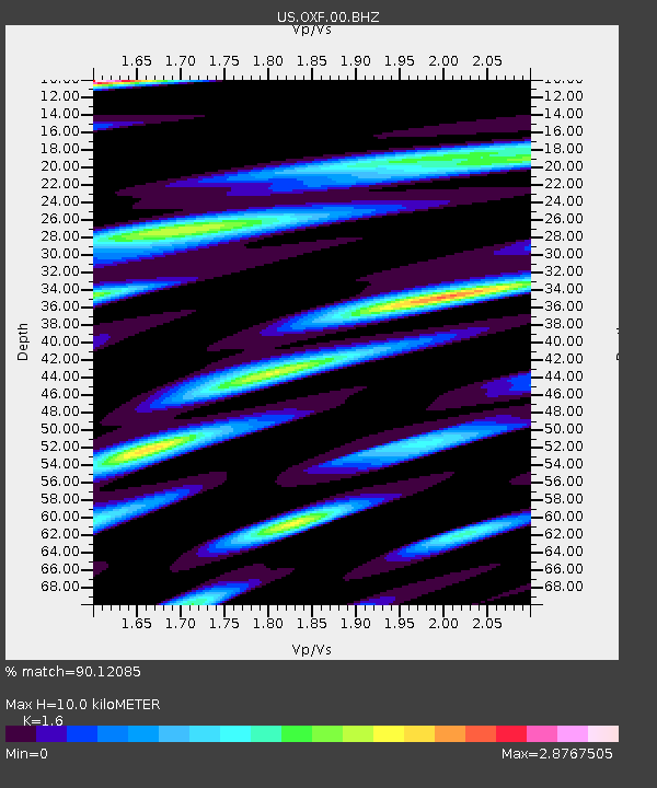
| Estimated Moho Depth: |
10.0 km |
| Estimated Crust Vp/Vs: |
1.60 |
| Assumed Crust Vp: |
6.38 km/s |
| Estimated Crust Vs: |
3.988 km/s |
| Estimated Crust Poisson's Ratio: |
0.18 |
|
| Radial Match: |
90.12085 % |
| Radial Bump: |
400 |
| Transverse Match: |
80.894615 % |
| Transverse Bump: |
400 |
| SOD ConfigId: |
626651 |
| Insert Time: |
2014-04-19 01:57:26.644 +0000 |
| GWidth: |
2.5 |
| Max Bumps: |
400 |
| Tol: |
0.001 |
|

Signal To Noise
| Channel | StoN | STA | LTA |
| US:OXF:00:BHZ:20131012T02:16:35.59899Z | 21.43889 | 3.0262177E-6 | 1.4115552E-7 |
| US:OXF:00:BH1:20131012T02:16:35.59899Z | 6.553162 | 2.0331634E-6 | 3.1025684E-7 |
| US:OXF:00:BH2:20131012T02:16:35.59899Z | 8.326847 | 2.4209044E-6 | 2.907348E-7 |
| Arrivals |
| Ps | 1.0 SECOND |
| PpPs | 3.7 SECOND |
| PsPs/PpSs | 4.8 SECOND |


